- DOI: 10.31509/2658-607x-202363-137
METHODS AND OPEN SOURCE MACHINE LEARNING GIS TOOLS FOR FOREST TRANSPORT MODELLING
![]()
Original Russian Text © 2023 E. S. Podolskaia published in Forest Science Issues Vol. 6, No 3, Article 130.
© 2023 E. S. Podolskaia
Center for Forest Ecology and Productivity of the Russian Academy of Sciences
Profsoyuznaya st. 84/32 bldg. 14, Moscow, 117997, Russian Federation
E-mail: podols_kate@mail.ru
Received: 05 July 2023
Revised: 22 September 2023
Accepted: 23 September 2023
Paper describes machine learning (ML) methods and tools for transport modelling to access forest fires and forest resources by ground means in the regions of Russia. Forestry transport accessibility requires further investigation and improvement. ML methods play an essential role in the detection of changes and automated data collection for transport infrastructure. We have analysed the recent scientific publications of two systems, namely CyberLeninka, a Russian electronic library, and ResearchGate, a social networking portal for scientists and researchers. It should be noted that, as of autumn 2023, these systems had a small number of papers on ML applications in the forestry transport modelling. Plugins from Open Source QGIS repository were studied. An increase in the number of ML plug-ins from the researchers and students could be expected, as individual developers and small research teams show a growing interest in the topic. ML prospects for ground transport modelling in the forestry are still underinvestigated.
Keywords: machine learning, Open Source, GIS, forestry, transport modelling
Transport modelling is a tool for planning and development of regions which is studied within many lines of research. One of the results of transport modelling in the forestry is the characterisation of transport accessibility necessary for the forest protection, conservation, and reproduction (Podolskaia, 2021).
Transport modelling to access the forest fires and forest resources remains relevant in Russia, since a significant part of the country’s forest reserves is located in remote and isolated areas. A number of scientific organisations work in the area of transport modelling in Russia, the key ones being the All-Russian Scientific Research Institute of Forestry and Forestry Mechanization (ARSRIFFM, or VNIILM in Russian) and the Center for Forest Ecology and Productivity of the Russian Academy of Sciences (CEPF RAS), as well as educational institutions, such as Mytishchi branch of Bauman Moscow State Technical University, Petrozavodsk State University, and Saint-Petersburg Kirov State Forest Technical University. As mentioned earlier (Podolskaia, 2021), each organisation has its own specialty in solving forest transport issues.
Machine learning (ML) as an artificial intelligence technology is currently attracting many researchers (Shyhaliev, 2020; Mihov et al., 2021); its methods are shown on the Fig. 1. Forest transport modelling requires the study of ML methods and tools in order to demonstrate their state-of-the-art capabilities in the area of processing existing and incoming vector and raster data, as well as identification of new infrastructural patterns in the forestry. ML methods are particularly promising for data collection, as well as for determining the infrastructural changes that have occurred, which is true for all areas of modern information technology, including geoinformatics.
In the forestry, machine learning methods help to solve various tasks, including classifying territories according to the infrastructural load and availability of firefighting facilities (fire-chemical stations, or FCS), and establishing correlations between the distribution of forest fires and infrastructural facilities using regression.
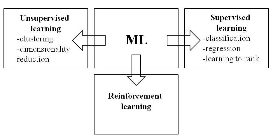
Figure 1. System of machine learning methods
(Source: Artificial Intelligence Tools and Platforms for GIS, 2023)
It is advisable to use the following ML methods to solve problems of modelling and assessing transport accessibility: random forests for zoning (Podolskaia et al., 2023), convolutional neural networks for detection of roads on satellite images (Podolskaia, 2022), and subsequent comparison with datasets from global sources such as OSM.
In recent years, there have been many publications on the use of ML methods in transport and logistics projects as well as in the assessment of natural resources. Little attention has been paid to the forest transport modelling so far, although this area combines the tasks of transport and economics and the specific features of forestry. In CEPF RAS, ML methods are a well-established practice in various projects; to cite one example, the random forest method is used for regression modelling of climate-regulating ecosystem services of forests (Narykova, Plotnikova, 2022; Plotnikova et al., 2022).
The objective of this work is to study the possibilities of ML methods and tools for the GIS project of ground transport modelling in the forestry of Russia. The tasks of the study are to analyse the number of published scientific papers found in the CyberLeninka and ResearchGate projects and to identify available Open Source GIS modules (tools) for forest transport modelling.
MATERIALS AND METHODS
Forest transport modelling of ground access using public, special-purpose (e. g., for forest use), or temporary (e. g., winter) roads is a hybrid area at the confluence of transport and forestry. Due to the narrow thematic scope of this topic, the number of publications using ML is rather limited.
For the analysis, data from two different systems (a Russian scientific library and a European academic network) were used to search for scientific papers in Russian and foreign (mainly English) languages. Search in the CyberLeninka scientific electronic library in September 2023 have shown that papers containing key phrase “machine learning in the forest transport modelling” present about 20% of the total number of papers dedicated to the machine learning in the forestry. Similar result was obtained by searching in the CyberLeninka, summer of 2021. Search by the key phrase “machine learning in the forest transport modelling” (the first 20 pages of search results) on ResearchGate, free European social network and hub for collaboration of scientists and researchers, showed two thematic groups of papers with several examples in each. The first group includes papers on the use of ML methods in transport projects, where the authors mention the insufficient use of ML advantages (Behrooz, Hayeri, 2022). Same group has researches implementing ML methods in the economic estimates of road construction cost (Jaafari et al., 2021). The second group includes papers on the recognition of quantitative and qualitative characteristics of forests on the satellite images (Mihajlov, Saj, 2017) and papers dedicated to the natural resources. An example of student research is a master’s thesis on ML methods for assessing and mapping forest resources defended at Saint-Petersburg State University (Snytkina, 2020). Based on the review results, it can be argued that the most popular ML methods for the forestry are k-nearest neighbour (k-NN), support vector machine (SVM), and variants of decision trees.
Relevant tasks of ML in the forest transport modelling of ground access include the most popular tasks in cartography and geoinformatics (Kolesnikov et al., 2018), that are:
- classification ― assigning an object to one of the categories based on its characteristics (Mihajlov, Saj, 2017);
- regression ― prediction of one or several quantitative characteristics of an object based on a set of its other features (Narykova, Plotnikova, 2022; Plotnikova et al., 2022);
- clustering ― division of a set of objects into groups based on the characteristics of these objects (module example: https://gis-lab.info/qa/qgis-attr-based-clust.html).
The experience of the Transport Issue Team of the Laboratory for Forest Ecosystems Monitoring of the CEPF RAS includes modelling of ground access for special firefighting machinery by roads of different classes using research regression for forest fires and infrastructural data. The group uses a variety of software tools, focusing on Open Source tools, of which the QGIS Open Source GIS package is the leading one. Plugins for solving ML tasks from the tool repository (https://plugins.qgis.org/plugins/tags/machine-learning/) are shown on the Fig. 2. The list of tools available in May–October 2022 (Cluster Points, Deep Learning Datasets Maker, EnMap-Box3, and Mapflow) has increased and, as of September 2023, included 6 items (Fig. 2). All of these plugins have been uploaded to the repository since 2020.
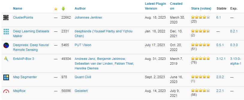
Figure 2. QGIS plugins with the tag ‘machine learning’
We plan to develop forestry QGIS plug-ins with OSM layers for the settlements and road network, an archive of forest fires detected by the MODIS system, and routes to access the forest fires by ground means made according to the methodology and GIS technology developed and implemented at the Laboratory for Forest Ecosystems Monitoring of the CEPF RAS.
CONCLUSION
Paper shows the current state of ML methods use in solving problems of forestry and forest transport modelling; it includes a list of Russian organisations working on this topic and scientific papers available via the CyberLeninka electronic library and the ResearchGate network. A brief overview of the Open Source QGIS plugins for ML in forest transport modelling was performed.
In the long term, one can expect that the number of plugins will slowly increase and their functionality will become more complex. The field of GIS tools for transport modelling in the forestry, which is an area of ML methods application, remains quite small due, firstly, to the fundamentally hybrid character of the topic and, secondly, to the certain versatility of available GIS plugins from the repository. Reasoning from experience in studying the history and results of plugin development, one could also assume that most of these thematic transport and forestry tools will be created within the framework of research papers or academic qualifying papers. Open Source Python libraries, such as Keras, Scikit-learn, PyTorch, and NumPy, are being in active use for ML. There are some plans to use ML methods for transport modelling of ground access in creating estimates and scenarios of the spatial arrangement of fire-chemical stations in fire-prone regions of Russia.
FINANCING
Author thanks the Center for Forest Ecology and Productivity of the Russian Academy of Sciences (CEPF RAS) for supporting their research by the state funding contract 2024–2026 “Biodiversity and ecosystem functions of forests”, registration number № 124013000750.
REFERENCES
Behrooz H., Hayeri Y. M., Machine learning applications in surface transportation systems: a literature review, Applied Sciences, 2022, Vol. 12, pp. 1–29. https://doi.org/10.3390/app12189156
Jaafari A., Pazhouhan I., Bettinger P., Machine learning modeling of forest road construction costs, Forests, 2021, Vol. 12, pp. 1–15. https://doi.org/10.3390/f12091169
Kolesnikov A. A., Kikin P. M., Komissarova E. V., Kasyanova E. L., Use of machine learning technologies in decision of geoinformational tasks, Proceedings of the International conference “InterCarto. InterGIS”, 2018, Vol. 24 (2), pp. 371–384.
Mihajlov E. V., Saj S. V., Vydelenie lesa na kosmicheskih snimkah s pomoshh’ju metodov mashinnogo obuchenija (Forest identification on the satellite imagery using machine learning methods), Doklady TUSURa, 2017, Vol. 20, No 1, pp. 89–92, DOI: 10.21293/1818-0442-2017-20-1-89-92
Mihov O. M., Shatalova N. V., Borodina O. V., Vasil’ev Ju. I., Primenenie tehnologij mashinnogo obuchenija dlja Drone Network v logistike i portovoj dejatel’nosti Rossii (Application of machine learning technologies for Drone Network in logistics and port activities in Russia), Morskie intellektual’nye tehnologii, 2021, No 4, Vol. 1, pp. 149–157.
Narykova A. N., Plotnikova A. S., Podgotovka prediktorov dlja modelirovanija klimatoregulirujushhih jekosistemnyh uslug lesov na regional’nom urovne s pomoshh’ju Google Earth Engine (Preparation of predictors for modeling climate-regulating forest ecosystems services at regional level using Google Earth Engine), Nauchnye osnovy ustojchivogo upravlenija lesami: Materialy Vserossijskoj nauchnoj konferencii s mezhdunarodnym uchastiem, posvjashhennoj 30-letiju CEPF RAS. M.: CEPF RAS, 2022, pp. 182–184.
Plotnikova A. S., Savin M. S., Lukina N. V., Teben’kova D. N., Kolycheva A. A., Chumachenko S. I., Shanin V. N., Kartografirovanie klimatoregulirujushhih jekosistemnyh uslug lesov na lokal’nom urovne (Mapping of forest climate-regulating ecosystem services at the local level), Nauchnye osnovy ustojchivogo upravlenija lesami: Materialy Vserossijskoj nauchnoj konferencii s mezhdunarodnym uchastiem, posvjashhennoj 30-letiju CEPF RAS. M.: CEPF RAS, 2022, pp. 190–192.
Podolskaia E. S., Obzor opyta reshenija zadach transportnogo modelirovanija v lesnom hozjajstve (Review of experience in solving transport modelling problems in the forestry), Voprosy lesnoj nauki, 2021, Vol. 4, No 4, pp. 1–32, DOI: 10.31509/2658-607x-2021-44-92.
Podolskaia E. S., Ispol’zovanie dannyh distancionnogo zondirovanija Zemli iz kosmosa dlja raspoznavanija izobrazhenija dorog v lesnom hozjajstve (Using Earth remote sensing data from space for road image recognition in the forestry), Voprosy lesnoj nauki, 2022, Vol. 5, No 4, pp. 1–21, DOI 10.31509/2658-607x-202252-115
Podolskaia E. S., Ershov D. V., Kovganko K. A., Infrastrukturnoe zonirovanie territorii dlja opredelenija svjazej s lesnymi pozharami (na primere Krasnojarskogo kraja, Rossija), (Infrastructure zoning of the territory for determination of links with forest fires (on the example of Krasnoyarsk Territory, Russia), Forests of Russia: politics, industry, science, education: Materials of the VIII All-Russian Scientific and Technical Conference, May 24–26, 2023, St. Petersburg, St. Petersburg State Forest Technical University named after S. M. Kirov, 2023, pp. 330–333.
Shyhaliev R. G., Issledovanie sovremennogo sostojanija primenenija mashinnogo obuchenija v neftegazovoj otrasli (A study of current state of machine learning application in the oil and gas industry), İnformasiya texnologiyaları problemləri, 2020, No 2, pp. 52–60. DOI: 10.25045/jpit.v11.i2.05
Snytkina D. A., Primenenie metodov mashinnogo obuchenija pri ocenke i kartografirovanii prirodnyh resursov (Application of machine learning methods for assessing and mapping of natural resources): Magisterskaja VKR (spec. 05.04.03), St. Petersburg: SPbGU, 2020, 92 p.
Reviewer: Candidate of Technical Sciences Khvostikov S. A.


