- DOI 10.31509/2658-607x-202364-138
DYNAMICS OF FOREST VEGETATION DESTRUCTIONS IN THE MINERALS EXTRACTION AREA OF THE NORTHERN COPPER ZINC MINE IN THE SVERDLOVSK REGION
![]()
Original Russian Text © 2023 A. E. Kvashnina, F. K. Vozmitel, V. A. Khamedov published in Forest Science Issues Vol. 6, No 1, Article 122.
© 2023 A. E. Kvashnina1*, F. K. Vozmitel1, V. A. Khamedov2,3
1“Denezhkin Kamen” Russian Federal Nature Preserve,
Lenina Str. 6, Severouralsk, 624480, Russia
2Siberian State University of Geosystems and Technologies,
Plakhotnogo Str. 10, Novosibirsk, 630108, Russia
3Saint-Petersburg State University of Aerospace Instrumentation,
Bolshaya Morskaia Str. 67, Saint-Petersburg, 190000, Russia
*E-mail: zapov.dk@gmail.com
Received: 01.03.2023
Revised: 20.03.2023
Accepted: 22.03.2023
Based on the Earth remote sensing data, the authors assessed the dynamics of forest vegetation area destructed under the impact of uncontrolled underspoil runoff from the Northern copper zinc mine in the northern Sverdlovsk Region. Interpretation of a series of satellite images for the period from 2009 to 2022 revealed an exponential increase in the destroyed forest vegetation area. The researchers designed a runoff digital model, which confirmed the correlation of vegetation destruction foci with specific landforms.
Keywords: remote sensing, satellite image interpretation, hydrological analysis, runoff model, forest vegetation destruction, ore mine
There are two open pits, Shemursky and Novo-Shemursky, mined by Svyatogor, Joint-Stock Company, being a part of Ural Mining and Metallurgical Company (UGMK), in the north of the Sverdlovsk region, at the distance of 3 and 5 km from the eastern border of «Denezhkin Kamen» nature preserve, on Shemur range. Since 2008, copper and copper zinc pyrite ores have been surface mined in the pits. The pits are mined at the top of the range with steep slopes (the range height is 700 m above the sea level, and its slopes are 21% to 40%), therewith pyrites-containing dumps located on the slopes contributes to formation of stream flows of the Bannaya, Chernaya, Olkhovka and Tamsher rivers actively. The Bannaya and Chernaya rivers are tributaries of the Taltiya river, while the Olkhovka and Tamsher rivers are tributaries of the Shegultan river. The Taltiya and Shegultan rivers are important stream flows of «Denezhkin Kamen» nature preserve; they originate from its territory. In 2018, contamination of all above-mentioned rivers with heavy metals and the areas with destructed forest vegetation were found (Kvashnina, Vladimirova, 2019; Vladimirova, Kvashnina, 2019; Kvashnina, 2022). In addition to the operating pits Shemursky and Novo-Shemursky, the Northern copper zinc mine includes Tarnierkiy pit, where mining operations were halted in 2014.
Assessment of the man-made contamination impact on composition and properties of the ground waters as a factor of affecting the condition of the vegetation cover is one of the most significant targets in ensuring environmental safety of the mining regions and minerals excavation (Ershov, 2020). Thus, this paper is aimed at modelling the dynamics of destructed forest vegetation areas increase in the territory affected by uncontrolled underspoil runoff at the Northern copper zinc mine by interpretation of the series of satellite images for the period of 2009 to 2022.
Satellite images with medial spatial resolution are widely used for studying vegetation damages in various topical tasks (Khamedov et al., 2006; Baumann et al., 2014). The use of the remote sensing data in this study allowed for modelling the vegetation destruction processes near the protected zone of the nature preserve that had not been identified before. It also enhanced the efficiency of on-site inspections by allowing simultaneous coverage of a large area.
MATERIAL AND METHODS
To determine the sources and pathways of contaminants intrusion into the stream flows of the Bannaya, Chernaya, Tamsher and Olkhovka rivers, the digital terrain model (DTM) was created based on 1:25,000 and 1:50,000 scale topographical maps. The pixel size of the DTM was 10×10 m, which allowed for smoothening local depressions and eliminating minor errors and inaccuracies of the model.
Based on the DTM, a flow direction bitmap was created indicating runoff from each cell to the closest adjacent cell down the steepest slope. Subsequently, a flow accumulation bitmap was developed for the mining area, representing the cumulative runoff into each cell. After linking the mouth points to the cells with the maximum cumulative runoff, the bitmaps of river catchment areas and drainage basins areas were created based on runoff direction bitmap. The hydrological analysis of the DTM and the development of the runoff model were performed using the ArcGIS Pro toolset.
To determine the presence and the scale of vegetation degradations caused by contaminants runoff, the series of Landsat-5, 7 and Sentinel-2 images for the summer season of 2006 to 2022 were analysed. The combination of short-wave infrared 1 (SWIR1), near infrared (NIR) and red channels was used on Landsat images. To analyse Landsat-5 images, we used the combination of B5-B4-B3 channels, while B6-B5-B4 channels were utilised for Landsat-7 images. To analyse Sentinel-2 images, the combination of short-wave infrared 1 (SWIR1), near infrared 8 (Vegetation Red Edge 8) and red, or B11-B8а-B4 channels was employed. The combination of channels in the red part of the spectrum typically provides the best detection of vegetation degradations (Krylov et al., 2011; Nikitina et al., 2019; Elsakov, 2021).
To verify the processes registered based on the remote sensing data, on-site inspections of the destructed forest vegetation areas in Bannaya, Olkhovka, Tamsher river valleys, and the survey with the use of an unmanned aerial vehicle were carried out.
RESULTS AND DISCUSSION
The obtained results of analysis of the plotted runoff map demonstrate that the Tarniersky pit drains into the Mundyr river (Ivdel river tributary) and into unnamed stream flow inflowing to the Taltiya river. The runoff from Shemursky pit drains to the Bannaya river (Taltiya river tributary) and unnamed stream flow that is a tributary of the Chernaya river (inflowing to the Taltiya river). The runoff from the storage sites of weakly mineralised solids and sulfuric pyrites is accumulated in the Tamsher river (Shegultan river tributary). The runoffs from Novo-Shemursky pit contribute to formation of the Olkhovka and Tamsher rivers, which are the Shegultan river tributaries. Fig. 1 shows the prepared map of the cumulative runoff from the Northern copper zinc mine facilities subject to contamination. The red colour in the figure shows stream flows with the maximum cumulative runoff, and the green colour shows those with the minimum one. The designed catchment areas involved in the formation of stream flows on the surveyed territory are indicated by different blue tones. The pit areas on the map are outlined in black, the «Denezhkin Kamen» nature preserve boundaries are outlined in red, and the protected zone of the nature preserve is outlined in green.
The study of changes in forest vegetation based on the satellite survey data revealed vegetation die-off in the Tarniersky mining area began in 2010, and, by 2015, the forest degradation started occurring in the Tamsher and Olkhovka river valleys.
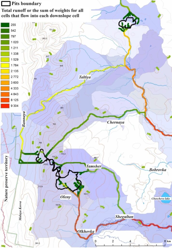
Figure 1. Cumulative runoff from the territory of the Northern copper zinc mine facilities and designed drainage area involved in the formation of stream flows
According to the satellite data, the degradation foci confine to the rivers into which the pits drain (Fig. 2) and completely follow the designed runoff model. The degraded forest vegetation areas are indicated by the red circle in the figure, with a Sentinel-2 image in the B11-B8а-B4 channel combination, taken on 23 August 2021, used as the background.
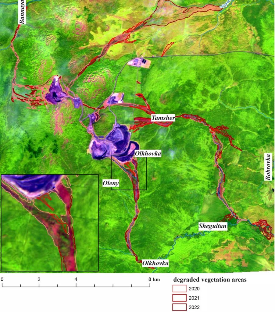
Figure 2. Fragment of Sentinel-2 satellite image with degraded vegetation areas
According to the remote sensing data, no significant degradations of the forest vegetation were found on the territories not subject to the impact of runoffs from the dumps. This observation was confirmed by field surveys. However, on-site inspection within the areas subject to the impact revealed the presence of small areas under the forest canopy where herb and subshrub vegetation layers degradation begins, which was not detected by the satellite imagery.
The analysis of the correlation between vegetation degradation foci and landforms demonstrated that approximately 80% of the foci are situated on gentle slopes (with max. 30% drift), where pollutants tend to accumulate. The mass degradation of vegetation is also observed on wetlands. The vegetation die-off signs are less pronounced on the steeper slopes. For example, the area of the degraded vegetation is minimal along the Bannaya river on the western slopes of the Shemur Range with a drift above 35%.
Since 2018, the territory on which the forest vegetation degradation was detected is increasing exponentially. In 2019, the degraded vegetation area was 379.4 ha, in 2020 it was approximately 662.1 ha, in 2021 it reached 712.5 ha, and by 2022 it increased to 1,149 ha (Fig. 3).
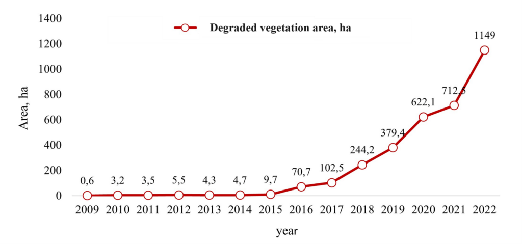
Figure 3. Dynamics of the degraded vegetation area within 2009–2022
Almost all areas of the degraded forest have slightly increased widthwise, with some also extending in length. The degraded forest area has significantly increased in the Tamsher river mouth, along the Shegultan river, and in the flat section of the Tamsher river valley. The signs of vegetation degradation were recorded in the lower reaches of the Bezymyannaya (Chernaya) river in 2021.
CONCLUSION
The remote sensing data allows for identifying the areas where the tree layer is degrading; however, the small patches with dead herbaceous and shrub vegetation cannot be detected using remote sensing methods. The data analysis demonstrates that widespread forest die-off is concentrated in river valleys receiving uncontrolled runoffs from copper and pyritic dumps of the Northern mine enter, and the dumps themselves. The territory on which the vegetation degradation was found has been exponentially increasing since 2018. The analysis of vegetation degradation foci confinedness to landforms using modelling revealed that approximately 80% of the foci are located on gentle slopes (with the drift of 30% maximum). The specific features of the areas where vegetation has degraded due to chemical poisoning of the soils differ from those affected by other negative factors, as all components of vegetation are observed to die. For example, in areas affected by bark beetle, herbaceous and shrub vegetation does not die; in areas affected by forest fires, herbaceous vegetation begins to recover the following year. However, in the studied areas of soil chemical contamination, vegetation recovery does not occur.
REFERENCES
Baumann M., Ozdogan M., Wolter P. T., Krylov A. M., Vladimirova N. A., Radeloff V. C., Landsat remote sensing of forest windfall disturbance, Remote Sensing of Environment, 2014, Vol. 143, pp. 171–179.
Elsakov V. V., Spektral’nye razlichija harakteristik rastitel’nogo pokrova tundrovyh soobshhestv sensorov Landsat (Spectral Differences in Vegetation Characteristics of Tundra Communities of Landsat Sensors), Sovremennye problemy distantsionnogo zondirovaniya Zemli iz kosmosa, 2021, Vol. 18, No 4, pp. 92–101.
Ershov V. V., Monitoring sostava atmosfernyh i pochvennyh vod v lesnyh jekosistemah: dostizhenija i perspektivy (Monitoring the composition of atmospheric and soil waters in forest ecosystems: achievements and prospects), Voprosy lesnoj nauki, 2020, Vol. 3, No 2, pp. 1–34.
Khamedov V. A., Kopylov V. N., Polishhuk Ju. M., Shimov S. V., Ispol’zovanie dannyh distancionnogo zondirovanija v zadachah lesnoj otrasli (The use of remote sensing data in the tasks of the forest industry), Sovremennye problemy distantsionnogo zondirovaniya Zemli iz kosmosa, 2006, Vol. 3, No 2, pp. 380–387.
Krylov A. M., Sobolev A. A., Vladimirova N. A., Vyjavlenie ochagov koroeda-tipografa v Moskovskoj oblasti s ispol’zovaniem snimkov Landsat (Identification of foci of bark beetle-typographer in the Moscow region using Landsat images), Forestry Bulletin, 2011, No 4, pp. 54–60.
Kvashnina A. E., Deshifrirovanie kosmosnimkov rajona raspolozhenija Severnogo medno-cinkovogo mestorozhdenija s cel’ju opredelenija vseh vozmozhnyh potokov zagrjaznennyh vod i ih vozdejstvie na okruzhajushhuju sredu (2021 g.) (Interpretation of satellite images of the location of the Northern copper-zinc deposit in order to determine all possible flows of polluted waters and their impact on the environment (2021)), Nauchnye issledovanija v zapovednikah i nacional’nyh parkah Rossijskoj Federacii (2015–2021 gg.), Vol. 5, Simferopol: Business-Inform, 2022, pp. 152–153.
Kvashnina A. E., Vladimirova N. A., Jekspress-ocenka posledstvij nekontroliruemogo podotval’nogo stoka na severnom medno-cinkovom rudnike i problemy zapovednika “Denezhkin kamen”, s nim svjazannye (Express assessment of the consequences of uncontrolled wastewater runoff at the northern copper-zinc mine and the problems of the Denezhkin Kamen reserve related to it), Geografija i sovremennye problemy geograficheskogo obrazovanija: materialy Vserossijskoj nauchno-prakticheskoj konferencii, posvjashhennoj 100-letiju so dnja rozhdenija Pochetnogo chlena Russkogo Geograficheskogo Obshhestva, doktora geograficheskih nauk, professora Vasilija Ivanovicha Prokaeva, Ekaterinburg: USPU, 2019, pp. 139–145.
Nikitina A. D., Knjazeva S. V., Gavriljuk E. A., Tihonova E. V., Jejdlina S. P., Koroleva N. V., Kartografirovanie dinamiki rastitel’nogo pokrova territorii nacional’nogo parka “Kurshskaja kosa” po materialam kosmicheskoj s’emki Alos i Sentinel-2 (Mapping the dynamics of the vegetation cover of the Curonian Spit National Park on the basis of Alos and Sentinel-2 satellite imagery), Voprosy lesnoj nauki, 2019, Vol. 2, No 3, pp. 1–21.
Vladimirova N. A., Kvashnina A. E., Ocenka masshtabov gibeli lesnyh jekosistem v rezul’tate razrabotki mestorozhdenij Severnogo medno-cinkovogo rudnika po serii kosmicheskih snimkov 2009–2018 gg (Estimation of the extent of the destruction of forest ecosystems as a result of the development of deposits of the Northern copper-zinc mine based on a series of satellite images in 2009–2018), Ajerokosmicheskie metody i geoinformacionnye tehnologii v lesovedenii, lesnom hozjajstve i jekologii: Doklady VII Vserossijskoj konferencii, CEPF RAS, 2019, pp. 29–31.
Reviewer: Doctor of Technical Sciences V. P. Stupin


