- DOI 10.31509/2658-607x-2020-3-1-1-12
Current and historical fire regimes of the Pechora-ilych nature reserve and its surroundings
![]()
Original Russian Text © 2019 A.O. Kharitonova, A.S. Plotnikova, D.V. Ershov, published in Forest Science Issues Vol. 2, No. 3, pp. 1-17
A.O. Kharitonova*, A.S. Plotnikova, D.V. Ershov
Center for Forest Ecology and Productivity of the RAS
Profsoyuznaya st. 84/32 bldg. 14, Moscow, 117997, Russia
*E-mail: Kharitonova@ifi.rssi.ru
Received 30 June 2019
Recurring fires have a significant impact on the dynamics and functioning of forest ecosystems. The fire regime determines conditions of occurrence, spread and long-term consequences of forest fires. A significant change in the fire regime in the natural complex may indicate at possible loss risks of the key components of the ecosystem. This study presents current and historical fire regimes mapping results for the Pechora natural reserve and its surroundings – Kurinsky and Yakshinsky forest districts. The input dataset consists of fire historical fires records for the area taken from several sources: historical fires dataset of the Pechora natural reserve covering period from the second half of the XIX century till nowadays, which was received from both satellite images interpretation and reserve’s records archive analysis; hot spots detected by airborne-based and ground-based means covering period from 1987 to 2011 and the dendrochronological reconstruction of fires in the pine forests of the reserve’s surroundings for a 600-year period. We applied a methodology of mapping forest ecosystems fire regimes at local level for mapping both current and historical fire regimes. The methodology is based on the LANDFIRE classification, which accounts for fires frequency and fires severity. Results analysis of historical fire regimes indicate the dominance of “less than 200 years” fire return rate, associated with low-to-moderate fire severity for the most of the area. As an exception, the mountainous part of the Pechora natural reserve is characterized by a long period of fire return rate. The analysis of current fire regimes has revealed long periods of fire recurrence in both the reserve area and the forest districts area. We also showed a human impact on the increase in fire frequency. An assessment of the deviation of current fire regimes from their historical values showed that current fire regimes are within their normal historical range in most of the study area.
Key words: fire regime, the Pechora-Ilych Nature reserve, LANDFIRE, FRCC, GIS analysis
The repeated impact of fires is considered an exogenous local catastrophic factor leading to the transformation of natural systems (Val’ter, 1974). Fires have a significant impact on the functioning of landscapes, which is locally manifested in microclimatic changes, changing of hydrological regime, changing of soil properties, increasing of mosaic pattern, disappearing of native and spreading of invasive flora and fauna species. The forests exposed to fires lose their resistance to subsequent fires, become more vulnerable to insect pests and external negative factors in general. Thus, about one third of the forest areas exposed to catastrophic fires in Russia turn into unproductive territories, where the process of natural reforestration is disrupted for several centuries (Shvidenko et al., 2011).
Changes in quantitative and qualitative characteristics of individual components and natural complexes in general largely depend on fire frequency and severity. Fires of low and medium severity result in decreased thickness of the litter and peat layer; burned out the ground vegetation, died of the undergrowth partially, and unevenly thinned of the forest canopy. At the same time, soil productivity increases in the first years after the fire, and the mosaic pattern contributes to landscape diversity increasing. Severe fires usually completely destroy the forest litter, ground vegetation and undergrowth. In addition, the stands are significantly thin out, the soil is subjected to desiccation and erosion, coniferous species are replaced by secondary deciduous forests (Melexov, 1980).
Depending on natural conditions, fire severity and fire return interval within natural complexes and their combinations special “pyroecological” regimes are formed (Furyaev et al., 1996). Russian scientists and foreign researchers use the concept of “fire regime” (Agee, 1993; Valendik, Ivanova, 2001; Sheshukov et al., 2008; Shvidenko, Shhepashhenko, 2013). Despite different approaches to fire regime definitions, the researchers agree that it determines the conditions for the occurrence, spread and long-term consequences of forest fires. There are also a number of regional features of fire regimes depending on forest vegetation, anthropogenic and climatic conditions.
For a number of years, the Center for Forest Ecology and Productivity of the RAS carried out research at aimed at developing methodological bases for determining and mapping fire regimes at various spatial levels – from local (Plotnikova et al., 2018) to national one (Plotnikova et al., 2016). This paper analyzes the results of current and historical fire regimes mapping within the Pechora-Ilych reserve and its surroundings, as well as determines the deviations of current fire regimes from their historical values.
STUDY AREA
To determine and analyze fire regimes at the local level, we chose the territory of the Pechora-Ilych biosphere reserve and its surroundings – the Kurinsky and Yakshinsky forest districts. This study area was chosen because there are spatially coordinated data on fire history (Alejjnikov et al., 2015; Lupyan et al., 2013; Drobyshev et al., 2004).
The Pechora-Ilych reserve is an important natural reserve which, together with the National Park “Yugyd Va”, is included in the UNESCO World Heritage List of natural sites as “Virgin Komi Forests”. The territory of the reserve is represented by two plots – the Ural mountainous and Yakshinsky ones (Fig. 1). The territory is located at the junction of two physical and geographical countries (the Russian Plain and the Urals mountain country), which explains high variability of natural landscapes. The border of the subzones of the middle and northern taiga is located on the studied territory, and this is also where the rivers of the largest basins – of the Pechora, Volga, Northern Dvina and Ob rivers – originate. In terms of geomorphology and landscape the area is divided into three regions from west to east, i. e. plain, foothill and mountain. The plain region is located within the Pechora lowland with an average absolute altitude of 95–150 meters. The landscape is characterized by aqueoglacial and morainic plains with undulating relief. The foothill region is characterized by a general slope to the west and absolute altitudes of 220–250 meters. In the eastern region there are two major ridges, i. e. the western (High Parma) and eastern (Ebel-iz, Valgan-chugra, Lyaga-chugra, and Shejim-iz) hills. The average absolute altitude of the peaks of the mountainous region is 750–850 meters, with some peaks rising up to 1.000–1.200 meters (Varsanof’eva, 1940).
The climate of the territory is moderately continental, nevertheless the meteorological indicators of individual landscape areas are somewhat different. In the plain region, the average annual air temperature is -0.8 oC, and in the north of the mountain area it is -4 oC. The annual precipitation in the plain region ranges from 500 to 800 mm, whereas in the mountain area it can be up to 1.000 mm (Zaboeva et al., 2013). It should also be noted that in the mountainous region at an altitude of 800–1,000 m frost weathering and cryogenic processes in the upper soil horizons are observed.
The vegetation cover of the study area varies depending on the landscape area (Fig. 2). Swamp ecosystems with numerous dwarf shrubs and green moss cover account for a significant part of the plain region of the reserve. The western part of the district is dominated by pine forests and swamps of the Pechora lowland (Gavrilyuk et al., 2018). The foothill region is characterized by dark coniferous forests of Siberian spruce with an admixture of fir. The area is also interspersed with hummock-ridge bogs, as well as secondary small-leaved (birch, aspen) and mixed forests representing different stages of pyrogenic successions. Dark coniferous forests, crooked forests, meadows, mountain tundra and goltsy (bare rocks) of the Northern Urals are common in the mountainous region. The Yakshinsky part of the reserve and the forest districts are dominated by pine forests of various types, i. e. lichen, green-moss, sphagnum forests, and there also are upland and transitional swamps. Valleys of the Pechora and Ilych rivers and their numerous tributaries developed communities of meadows, thickets of shrubs and massifs of hummock-ridge bogs. Primary herb-type birch forests grow in the floodplain of the Pechora river (Lavrenko et al., 1995).
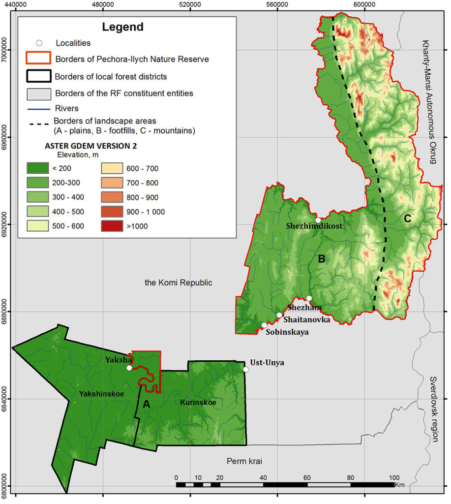
Figure 1. Relief of the study area according to the ASTER GDEM V2
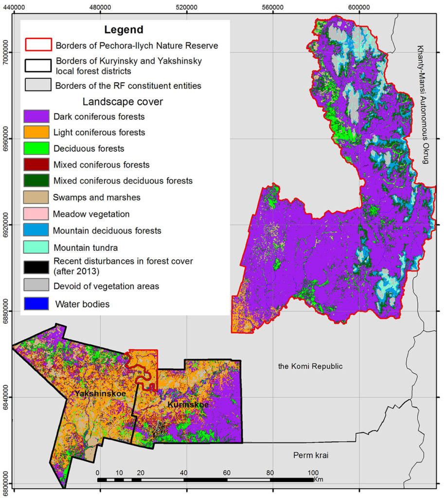
Figure 2. Vegetation of the Pechora-Ilych Nature reserve and its surroundings
Mapping of fire regimes was performed using data on the fire history of the study area from several sources (fig. 3). First, it was the history of fires in the Pechora-Ilych Nature reserve from the second half of the 19th century, resulting from satellite images interpretation and reserve’s records archive analysis (Alejjnikov et al., 2015). Second, hot spots detected by airborne-based and ground-based means covering period from 1987 to 2011 throughout the study area, specifying fire area and pattern (crown or ground fire) (Lupyan et al., 2013). Third, dendrochronological reconstruction of fires in pine forests of the reserve surroundings for a 600-year period, available on the territory of some spatial units of the Kurinsky and Yakshinsky forest districts (Drobyshev et al., 2004).
In accordance with the developed method of fire regimes mapping at the local level, the first stage of the study involved the identification of spatial units (Plotnikova et al., 2019) which were understood as the largest area with a relatively uniform nature of damage (Price, Daust, 2003). At the local level, it was proposed to use spatial units based on the boundaries of river basins (Plotnikova, Kharitonova, 2018). The indicators of forest fire statistics, such as the number of fires, the proportion of the area covered by fire, the average fire area and its standard deviation during the study period, the predominant type of vegetation were determined for each river basin with retrospective statistical GIS analysis. Spatial units are rivers basins where one forest ecosystem type was predominant and long-term values of the main pyrological indicators were uniform. River basins not meeting these requirements were combined with neighbouring basins similar in terms of forest fire statistics and analyzed again. The obtained spatial unit boundaries for mapping fire regimes in the study area are shown at Figure 3.
During the second stage, fire regimes of spatial units were identified with the LANDFIRE classification (Landscape Fire and Resource Management Planning Tools) (https://www.landfire.gov). The LANDFIRE classification identifies five classes of fire regimes depending on the period of fire recurrence (0–35 years; 36–200 years; more than 200 years) and the severity of vegetation damage (low, medium, high) (Barrett et al., 2010). The research period is divided into two intervals, i. e. the historical and the current ones. The time frames of the fire frequency assessment intervals given in Table 1 are based on the initial data on the pyrological history of the study area.
Table 1. Fire frequency assessment intervals
|
Study area |
Intervals for assessing fire frequency |
|
|
Historical |
Current |
|
|
The Pechora-Ilych reserve |
1850–1986 |
1987–2014 |
|
Surroundings of the reserve |
1424–1954 |
1987–2011 |
In accordance with the LANDFIRE method, for each spatial unit (k), the period of fire recurrence in the historical interval is first determined as the average number of years between fires (rFlk). Then the average annual area covered by fire over the historical interval is calculated as the ratio of the spatial unit area (STk) to the period of fire recurrence in the historical interval: rSFk=STk /rFlk. Next, the average annual area covered by fire over the current interval is estimated as the ratio of the spatial unit area covered by fire over the current interval ∑nj=1cSFkj to the number of years in this interval (n): cSFk=∑nj=1cSFkj/n.
Through these calculations we can find the adjusting factor (CCk), i. e. the ratio of the average annual area covered by fire over the historical interval to the average annual area covered by fire over the current interval: CCk=rSFk/cSFk Finally, the current period of fire recurrence is defined as the product of the period of fire recurrence of the historical interval and the adjusting factor: cFlk=rFlk×CCk .
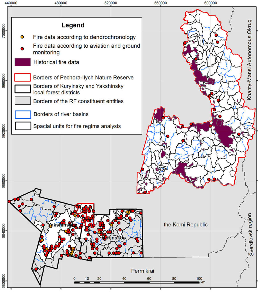
Figure 3. Fire history data and boundaries of spatial units for mapping fire regimes in the study area
To determine the dominant severity on the spatial unit, the data on hot spots detected by aviation and ground monitoring were used (Lupyan et al., 2013). The total area of crown and ground fires was calculated within the boundaries of the spatial units. Low/mixed severity of damage was considered predominant if the territory of the spatial unit was dominated by ground fires. Conversely, highly severe damage was considered predominant in case of prevailing crown fires.
RESULTS AND DISCUSSION
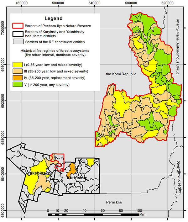
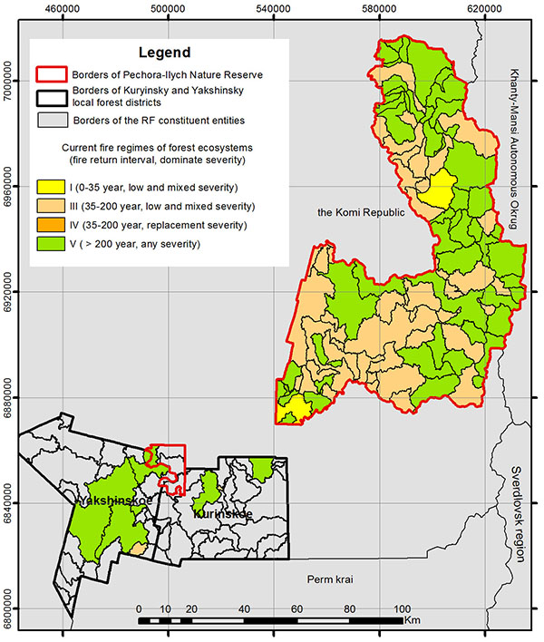
Mapping of fire regimes at the local level made it possible to create maps of current and historical fire regimes of the Pechora-Ilych reserve and its surroundings (Fig. 4a, 4b). Please note that on the territory of the Kurinsky and Yakshinsky forest districts, fire regimes were defined only for those spatial units for which the data of dendrochronological reconstruction of fires were available (Drobyshev et al., 2004).
 |
 |
|
A |
B |
Figure 4. Fire regimes of the Pechora-Ilych reserve and surrounding areas:
A) historical, B) current
These new maps revealed the territorial heterogeneity of historical and current fire regimes within the study area. In the historical period, most spatial units were characterized by fire regime class I (fire return interval 0–35 years, low and mixed severity) and III (36–200 years, low and mixed severity) with the exception of the mountainous part of the reserve. For instance, class I is identified in the territory of the reserve in close proximity to the Ilych river. The fire return rate is high (0–35 years) here, mainly due to anthropogenic factors, since the Ilych river has been an important traffic artery. Human influence had a great impact on fire frequency because there was no environment protection in place: the Pechora-Ilych reserve became a protected territory only in 1930. The majority of the spatial units of the foothill region possess fire regime of class III, which means a fairly long fire recurrence period (36–200 years) without changes in the species composition. In the mountainous part of the reserve, fires occurred very rarely and only within a few spatial units, so they are characterized by class V fire regime (the period of fire recurrence: over 200 years, the change of species composition, any severity of damage). The long period of fire recurrence in the mountainous part (more than 200 years) is due to both natural, mainly climatic and orographic, and anthropogenic factors such as the inaccessibility of territories for people. Large parts of the Yakshinsky forest district have class I fire regime due to pine forests predominating in the vegetation and being particularly vulnerable to the effects of ground fires in dry years (Fig. 2).
In the current period, most of the study territory is characterized by class V fire regime, largely due to absent anthropogenic activities since the designation of the territory as a protected area. Conspicuously, the territories adjacent to the floodplain of the Ilych river, which in the historical period were characterized by class I fire regime, now have class V. It can be assumed that the role of the pyrogenic factor in the development of forest ecosystems in this area has decreased significantly. Spatial units located outside the protected area also moved to class V. The foothill part of the reserve faced no significant changes in fire regimes as compared to the historical interval: class III still prevails. Moreover, only two spatial units located in the northern and southwestern parts of the reserve in different natural conditions are characterized by class I fire regime. The short period of fire recurrence in the southwestern part is explained by the predominance of pine in the stand.
The obtained maps allow us to estimate the deviation of the current fire regime from the historical values for each spatial unit. Foreign literature introduced the concept of fire regime condition class (FRCC), which is understood as a qualitative measure of deviation of the current fire regime from the historical one (Schmidt et al. al., 2002). Deviations of the fire regime lead to changes in the characteristics of key ecosystem components: species composition, structure and age of vegetation, canopy closure, presence and composition of fuels, which affects the change in fire frequency and intensity of fire spread. Unnatural accumulation of fuels resulting from human impact (fires, logging) is believed to be one of the reasons for the described deviations. For each fire regime, one of the three condition classes is determined to describe the potential risks to ecosystems (Table 2).
Table 2. Fire Regime Condition Classes and potential risks to ecosystems
There are several approaches to determining the FRCC depending on the estimated changes in: vegetation (FRCCVS), fire frequency (FRCCFRI), fire severity (FRCCSEV). In this study, FRCCFRI was found based on the deviation of current periods of fire recurrence from the historical ones (Fig. 5).
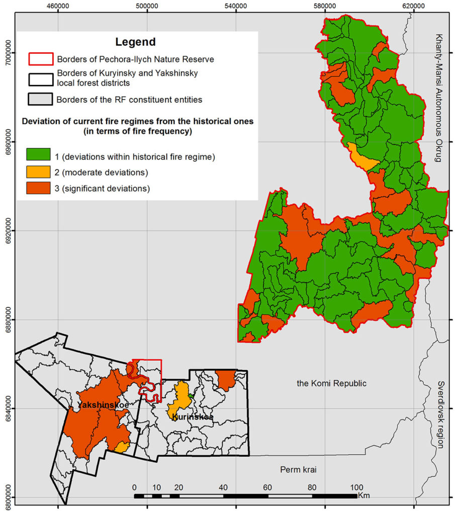
Figure 5. Deviation of current fire regimes from the historical ones (in terms of fire frequency)
Analysis of the deviation of current fire regimes from historical values showed that there were significant changes in fire frequency on the territories located in the foothills of the reserve in close proximity to the Ilych river, as well as in the considerable part of the Yakshinsky and northern part of the Kurinsky forest districts. Notably, this deviation means the reduction of fire frequency, which may affect the biodiversity of vegetation. According to Russian scientists, in the absence of fires the study area will become dominated by dark coniferous forests, and meadow flora will gradually decrease, which will lead to a certain decline in the vegetation diversity (Smirnova et al., 2015). Mountainous areas of the reserve were little affected by changes in the fire regime.
CONCLUSION
We obtained and analyzed the maps of current and historical fire regimes of the Pechora-Ilych Nature reserve and its surroundings within the framework of the study. The chosen methodological approach allowed us not only to determine the features of fire regimes of spatial units with different physical and geographical characteristics, but also to identify changes in fire regimes in the historical aspect.
Analysis of historical fire regimes showed that for the majority of the territory the period of fire recurrence was less than 200 years with low or mixed severity. An exception is the mountainous part of the Pechora-Ilych Nature reserve with a long period of fire recurrence. Current fire regimes of both the protected area and the investigated forest districts are characterized by long periods of fire recurrence. The changes in fire regimes are largely caused by anthropogenic factors – after the territory had been designated as protected area, the direct impact of economic activity was excluded, the periods of fire recurrence became longer. Moreover, increased periods of fire recurrence in the territory of forest districts may be a sign of timely detection and extinguishing of forest fires by the aviation forest protection service.
The assessment of the FRCC and potential risks to ecosystems showed that the current fire regimes of the majority of the study territory are within their historical values, therefore, the risks of loss of key ecosystem components are minimal.
ACKNOWLEDGEMENTS
The research was carried out with financial support from the Russian Foundation for Basic Research (project No. 17-05-00300), as well as within the framework of the state assignment АААА-А18-118052400130-7 “Methodological approaches to the assessment of the structural organization and functioning of forest ecosystems”.
Agee J.K., Fire ecology of Pacific Northwest forests, Island Press, Washington, D.C. 1993, 493 pp.
Alejjnikov A.A., Tjurin A.V., Simakin L.V., Efimenko A.S., Laznikov A.A., Istorija pozharov v temnokhvojjnykh lesakh Pechoro-Ilychskogo zapovednika so vtorojj poloviny XIX veka po nastojashhee vremja (The history of fires in dark coniferous forests of the Pechora-Ilych Reserve from the second half of the XIX century to the present), Sibirskijj lesnojj zhurnal, 2015, No. 6, pp. 31-42.
Barrett S.W., Havlina D., Jones J., Hann W., Frame C., Hamilton D., Schon K., Demeo T., Hutter L., Menakis J., Interagency Fire Regime Condition Class Guidebook, Version 3.0., 2010, URL: https://www.landfire.gov/frcc/frcc_guidebooks.php (July 23, 2018).
Drobyshev I., Niklasson M., Angelstam P., Majewski P., Testing for anthropogenic influence on fire regime for a 600-year period in the Jaksha area, Komi republic, East European Russia, Canadian Journal of Forest Research, 2004, Vol. 34, No. 10, P. 2027-2036.
Furyaev V.V., Kurbatskij N.P., Buzykin A.I., Rol’ pozharov v processe lesoobrazovaniya (The role of fires in the process of forest formation), Novosibirsk: Nauka, 1996, 252 p.
Gavrilyuk E.A., Plotnikova A.S., Plotnikov D.E., Kartografirovanie nazemnyx e’kosistem Pechoro-Ilychskogo zapovednika i ego okrestnostej na osnove vosstanovlennyx mul’tivremennyx sputnikovyx dannyx Landsat (Mapping of terrestrial ecosystems of the Pechora-Ilychsky Reserve and its surroundings based on reconstructed multi-time Landsat satellite data), Sovremennye problemy distancionnogo zondirovaniya Zemli iz kosmosa, 2018, Vol. 15, No. 5, pp. 141-153.
LANDFIRE Program, URL: https://www.landfire.gov (2019, 19 June).
Lavrenko A.N., Ulle Z.G., Serditov N.P., Flora Pechoro-Ilychskogo biosfernogo zapovednika, Saint Petersburg: Nauka, 1995, 255 p.
Lupyan E.A., Ershov D.V., Bartalev S.A., Isaev A.S., Informacionnaya sistema distancionnogo monitoringa lesnyx pozharov i ix posledstvij: rezul’taty poslednego desyatiletiya i perspektivy (Information System for Remote Monitoring of Forest Fires and Their Consequences: the Results of the Last Decade and Prospects), Pyataya Vserossijskaya nauchnaya konferenciya “Ae’rokosmicheskie metody i geoinformacionnye texnologii v lesovedenii i lesnom xozyajstve” (5th All-Russia Science Conference), Moscow, 22-24 April 2013, Moscow: CE’PL RAN, 2013, pp. 40-43.
Melexov I.S., Lesovedenie (Forest studies), Moscow: Lesnaya promyshlennost’, 1980, 406 p.
Plotnikova A.S., Ershov D.V., Shulyak P.P., Analiz statistiki pozharov v lesnom rajone dlya obosnovaniya vybora prostranstvennoj edinicy pri kartografirovanii pozharnyx rezhimov Rossii (Analysis of the statistics of fires in the forest area to justify the choice of spatial units in the mapping of fire regimes in Russia), Shestaya Vserossijskaya nauchnaya konferenciya “Ae’rokosmicheskie metody i geoinformacionnye texnologii v lesovedenii, lesnom xozyajstve i e’kologii” (6th All-Russia Science Conference), Moscow, 20-22 April 2013, Moscow: CE’PL RAN, 2016, pp. 206-207.
Plotnikova A.S., Kharitonova A.O., Ershov D.V., Metodologiya dinamicheskogo geoinformacionnogo kartografirovaniya pozharnyx rezhimov lesnyx ekosistem na lokal’nom urovne (The method aimed at dynamic forest fire regimes mapping over the local area), Sed’maya Vserossijskaya nauchnaya konferenciya “Ae’rokosmicheskie metody i geoinformacionnye texnologii v lesovedenii, lesnom xozyajstve i ekologii” (7th All-Russia Science Conference), Moscow, 22-24 April 2019, Moscow: CEPL RAN, 2019, pp. 168-170.
Plotnikova A.S., Kharitonova A.O., Ershov D.V., Metod opredeleniya pozharnyx rezhimov lesnyx ekosistem na lokal’nom urovne (Method for determining fire regimes of forest ecosystems at the local level), Vserossijskaya nauchnaya konferenciya “Nauchnye osnovy ustojchivogo upravleniya lesami” (All-Russia Science Conference), Moscow, 30 October – 1 November 2018, Moscow: CEPL RAN, 2018, pp. 88-89.
Plotnikova A.S., Kharitonova A.O., Vydelenie granic vodosbornyx bassejnov rek na lokal’nom prostranstvennom urovne (Identifocation of drainage basin borders at local spatial level), Electronic scientific journal “Forest science issues”, 2018, Vol. 1, No. 1. available at: https://jfsi.ru/1-1-2018-plotnikova_kharitonova/
Price K., Daust D., The frequency of stand-replacing natural disturbance in the CIT area, Report for the Coastal Information Team, 2003.
Schmidt K. M., Menakis J.P., Hardy C.C. et al., Development of coarse-scale spatial data for wildland fire and fuel management, Gen. Tech. Rep. RMRS-GTR-87, Fort Collins, CO: US Department of Agriculture, Forest Service, Rocky Mountain Research Station, 2002, Vol. 87, 41 p.
Sheshukov M.A., Brusova E.V., Pozdnyakova V.V., Sovremennye pozharnye rezhimy v lesax Dal’nego Vostoka (Modern fire regimes in the forests of the Far East), Lesovedenie, 2008, No. 4, pp. 3-9.
Shvidenko A.Z., Shhepashhenko D.G., Klimaticheskie izmeneniya i lesnye pozhary v Rossii (Climate change and forest fires in Russia), Lesovedenie, 2013, No. 5, pp. 50-61.
Shvidenko A.Z., Shhepashhenko D.G., Vaganov E.A. i dr., Vliyanie prirodnyx pozharov v Rossii 1998-2010 gg. na e’kosistemy i global’nyj uglerodnyj byudzhet (The impact of wildfires in Russia 1998-2010 on ecosystems and the global carbon budget), DAN, 2011, Vol. 441, No. 4, pp. 544-548.
Smirnova O.V., Shevchenko N.E., Smirnov N.S. Ocenka poter’ floristicheskogo raznoobraziya v osnovnyx tipax temnoxvojnyx lesov v verxov’yax reki Pechory (Estimation of the loss of floristic diversity in the main types of dark-coniferous forests in the upper reaches of the Pechora River), Trudy Pechoro-Ilychskogo gos. Zapovednika, 2015, pp. 147-153.
Teplova V.P., Xarakteristika nekotoryx gidroklimaticheskix pokazatelej i yavlenij v ravninnom rajone Pechoro-Ilychskogo zapovednika (Characteristics of some hydroclimatic indicators and phenomena in the flat region of the Pechora-Ilychsky Reserve), Trudy Pechoro-Ilychskogo gos. Zapovednika 2010, pp. 178-188.
Valendik E’.N., Ivanova G.A., Pozharnye rezhimy v lesax Sibiri i Dal’nego Vostoka (Fire regimes in the forests of Siberia and the Far East), Lesovedenie, 2001, No. 4, pp. 69-76.
Val’ter G., Rastitel’nost’ zemnogo shara, E’kologo-fiziologicheskaya xarakteristika (The vegetation of the globe, Ecological and physiological characteristics), Vol. 2: Lesa umerennoj zony, Val’ter Genrix, Moscow: Progress, 1974, 424 p.
Varsanof’eva V.A., Geologicheskoe stroenie territorii Pechoro-Ilychskogo gosudarstvennogo zapovednika (Geological structure of the Pechora-Ilychsky State Reserve), Trudy Pechorsko-Ilychskogo gosudarstvennogo zapovednika (Trudy of the Pechora-Ilych State Reserve), 1940, Vol. 1, pp. 5-214.
Reviewer: PhD in technology, research officer F.V. Stytsenko


