- DOI 10.31509/2658-607x-2020-3-1-1-8
Highly-detailed remote sensing monitoring of tree overgrowth on abandoned agricultural lands
С текстом оригинальной статьи Вы можете ознакомиться по ссылке
![]()
Original Russian Text © 2019 A.A. Medvedev, N.O. Telnova, A.V. Kudikov, published in Forest Science Issues Vol. 2, No. 3, pp. 1-12
A.A. Medvedev, N.O. Telnova*, A.V. Kudikov
Institute of Geography of the RAS
Staromonetny per., 29, Moscow, 119017, Russia
*E-mail: natalia.telnova@gmail.com
Received 01 July 2019
This paper presents the results of long-term remote monitoring of tree overgrowth on abandoned agricultural lands. This monitoring is based on multi-temporal satellite images with ultra-high spatial resolution and highly-detailed optical survey from Unmanned Air Vehicles (UAVs). Successful use of photogrammetric dense point clouds was demonstrated for three-dimensional reconstruction of tree canopy structure on abandoned agricultural lands by using the tree canopy height digital model. Spatial data were obtained on tree expansion on the fallow in 2005–2018, current tree canopy heights and its vertical growth, stem density, and canopy closure. The study revealed distinct spatio-temporal heterogeneity of tree overgrowth on the fallow. In the first years after land abandonment the most rapid regeneration and dispersal of trees occurred from the forests resulting in very dense but low tree cover adjacent to the forest. Later, tree overgrowth occurred in isolated hotspots and was characterized by very intensive vertical growth of the tree canopy.
Key words: Central Non-Chernozem region, fallows, post-agrogenic succession, UAVs, digital canopy height models.
Taking agricultural land out of cultivation and turning it into fallows with subsequent overgrowth of natural vegetation is a significant type of change in land cover and land use patterns in many countries worldwide. During the 20th century, about 70 million hectares of agricultural land were taken out of cultivation in Russia alone, about 2/3 of which – during the crisis of the late 1980s–1990s (Lyuri et al., 2010). Since the 2000s, the opposite trend has been observed in Eastern European countries, i. e. active taking previously abandoned arable lands up for cultivation, whereas the driving forces of this process show significant differences (Estel et al., 2015). These processes have also been observed in many regions of the European Russia, where large agricultural holdings play the main role in taking arable land abandoned in the 1990s–2000s up for cultivation (de Beurs et al., 2017). However, in the majority of the Central Non-Chernozem region, fallow agricultural land still occupies a significant area, and the removal of new land from cultivation is compensated by the expansion of arable land only at some local points. Macro-regional spatial patterns of the ratio between abandoned and currently used agricultural land in the Central Non-Chernozem region are clearly observed using multi-temporal data of medium-resolution remote sensing. The contour map shown in Fig. 1 is based on data from Lesiv et al., 2018, and reflects the spatial patterns of changes in the structure of arable land in parts of the Central Non-Chernozem region.
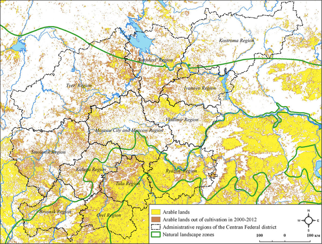
Figure 1. Distribution of arable and abandoned lands in parts of the Central Non-Chernozem region. Compiled according to data provided by (Lesiv et al., 2018)
The largest overgrowth of tree and shrub vegetation during the 2000s is observed in the northern part of the region within the landscape zone of mixed coniferous and broad-leaved forests in Smolensk, Tver, Kostroma, Yaroslavl, and Ivanovo regions (Fig. 1). The process of overgrowth is almost non-existent in the southernmost parts of the region within the forest-steppe zone (southern parts of Orel, Tula, and Ryazan regions). At the same time, a number of areas of the central Non-Chernozem region (Moscow, Kaluga, Tula, and Orel region) show more contrasting distribution pattern of the share of overgrown agricultural land, which is mainly confined to the territories located within the landscape zone of broad-leaved forests. Over the past 15 years, there have been diverse changes in the structure of land use, represented by both the overgrowth of tree and shrub vegetation on old fallows, and their re-plowing.
Numerous recent studies of remote indication and monitoring of non-cultivated agricultural land employ time series of remote sensing data (RSD) of low and medium resolution and are focused on analyzing patterns of spatio-temporal differentiation of changes in the structure of agricultural land use, determining the time of removing the land out of cultivation and the nature of overgrowth on fallow lands at the macro-regional and regional levels (Alcantara et al., 2013; Estel et al., 2017; Koroleva et al., 2018; Lesiv et al., 2018).
The objective of this study is to assess the speed of tree and shrub vegetation expansion on fallows within the landscape zone of broad-leaved forests and to reveal spatial heterogeneity of this process at the local level based on the integrated use of multi-temporal ultra-high-resolution remote sensing data from space and unmanned aerial vehicles (UAVs).
MATERIALS AND METHODS
We selected a plot of arable land in Dubensky rayon of Tula region, which was taken out of cultivation in the early 2000s as an object for studying the spatio-temporal features of post-agrogenic succession using multi-temporal data of ultra-high-resolution remote sensing (Fig. 2). The non-cultivated land is located on a levelled watershed surface and gentle slopes near the water dividing line, with small massifs of polydominant broad-leaved forests adjacent to it from the north and south. The plot area is about 1.5 ha. In the absence of anthropogenic disturbances, grazing and mowing in particular, since the termination of plowing, a herb-type birch forest has grown on the fallow. These communities are indicative of the intermediate stage of post-agrogenic succession typical for the zone of broad-leaved forests (Lyuri et al., 2010). The tree cover is dominated by the warty birch (Betula pendula) and downy birch (B. pubescens), which have formed a dense closed stand with sparse and depleted ground cover on most of the fallow.
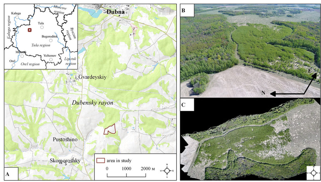
Figure 2. Layout of the studied object (A), oblique image from an UAV (B), and orthophotomosaic from UAV imagery (C)
We selected all multi-temporal satellite images of very high and ultra-high resolution relevant for the study area available in the archives: OrbView-3, Geoeye-1, Quickbird, and WorldView-2, which formed an intermittent time series for 2004–2015 (Table 1). To fill the chronological gaps in the overgrowth on fallows, from 2013 to 2018 an annual multi-season survey was conducted by various unmanned aerial vehicles (UAVs) at the altitude of 100 m.
Table 1. Main characteristics of archival satellite images
|
Image type |
Survey date |
Spatial resolution, m |
|
OrbView-3, panchromatic |
29.07.2004 |
1 |
|
Quickbird, RGB and panchromatic |
13.08.2007 |
0.6 |
|
WorldView-2, RGB and panchromatic |
21.05.2010 |
0.5 |
|
GeoEye-1, RGB and panchromatic |
23.07.2015 |
0.5 |
To extract the quantitative parameters of the tree-shrub vegetation growing on the fallow and their annual changes during 2013–2018, three-dimensional models obtained from the UAV survey data were used, i. e. photogrammetric dense point clouds sufficient to extract the quantitative parameters of tree vegetation in small areas, comparable in accuracy with the materials of airborne laser scanning (Dandois, Ellis, 2013). After removing the noise and classifying a single dense point cloud with the allocation of the «ground level» class, ultra-highly-detailed digital surface and terrain models are built on their basis. The arithmetical difference between the surface and terrain digital models can be interpreted as a digital model of tree canopy heights used to quantify and 3D model the structural parameters of tree and shrub vegetation and their changes over time (Lisein et al., 2013). To address the issue of tree canopy delineation in a dense closed stand, where the data from a summer UAV survey did not make it possible to obtain a sufficient number of points describing the ground level, we additionally used the materials of aerial surveys conducted during the dormancy of tree vegetation in late autumn and winter. That way we built a highly-detailed digital terrain model of the study area and multi-temporal digital models of the tree canopy heights with a spatial resolution of 6 cm and a vertical accuracy up to 5 cm (Table 2).
Table 2. Main characteristics of UAV aerial surveys and derived materials
|
UAVs and cameras used |
DJ Inspire, DJI Phantom 3, DJI Phantom 4 Pro RGB 16–20 MP cameras |
| Altitude levels of shooting |
100 m |
|
Shooting angle |
Nadir and oblique aerial photography |
| Images overlapping |
Over 80% |
|
Spatial resolution of single images |
1–2 cm |
| Average density of the dense point cloud |
Over 300 points per m2 |
|
DSM spatial resolution |
6 cm |
|
DSM vertical resolution |
5 cm |
|
Orthophotomosaic spatial resolution |
3–4 cm |
The number of trees and shrubs and their dispersal within the fallow was determined separately for each time slice provided by single satellite images based on photointerpretation. For UAV data, in addition to photointerpretation of trees by multi-season orthophotomosaics, automatic delineation of tree and shrub crown peaks was performed using a digital model of tree canopy heights by the surface local maxima method (Mongus, Žalik, 2015). Crown coverage required to determine the projective canopy coverage (crown closure) was calculated using an object-oriented segmentation algorithm for the tree canopy height model using the watershed-based method (Ke, Quackenbush, 2011). The accuracy of automatic detection of crown peaks was assessed based on the results of synchronous time recording of individual tree statistics and photointerpretation of individual trees, and, depending on the density of the tree canopy, amounted to 70–90 %.
As a result of visual and automated interpretation of highly-detailed RSD, spatial distributions of the following main structural parameters of the tree vegetation growing on the fallow were obtained for different time slices: stand density, tree canopy height, and crown closure. The use of multi-temporal materials from UAV surveys provided spatially-distributed data on the vertical growth of the tree canopy on the non-cultivated land.
RESULTS AND DISCUSSION
The analysis of a complex time series of RSD from space and unmanned aerial vehicles allowed us to reconstruct in detail the chronology of overgrowth of tree and shrub vegetation on the fallow and to identify individual stages of this process. The main indicator of spatio-temporal heterogeneity of post-agrogenic succession over the period of remote monitoring is the change of the density of trees and shrubs on the fallow land.
With the available intermittent time series of satellite images, we can date the time of land removal out of cultivation as 2005 at the earliest. Initially, the recovery of tree vegetation occurred from the forest edge, where several large clusters with a very high density of birch undergrowth had been already formed by 2007. In general, since 2004, there have been two periods of the most active expansion of tree and shrub vegetation on the fallow, i. e. 2007–2009 and 2013–2017. The latter period is characterized by the more active renewal of tree vegetation in the central part of the fallow, remoted from the adjacent woodlands, as well as along the western and eastern parts of the site sharing borders with the road and meadows in use (Fig. 3).
Visualization of the spatial distribution of the identified structural parameters of the stand growing on the non-cultivated land revealed several patterns of post-agrogenic regeneration of tree vegetation, depending on their location in relation to the neighbouring forests (Fig. 4).
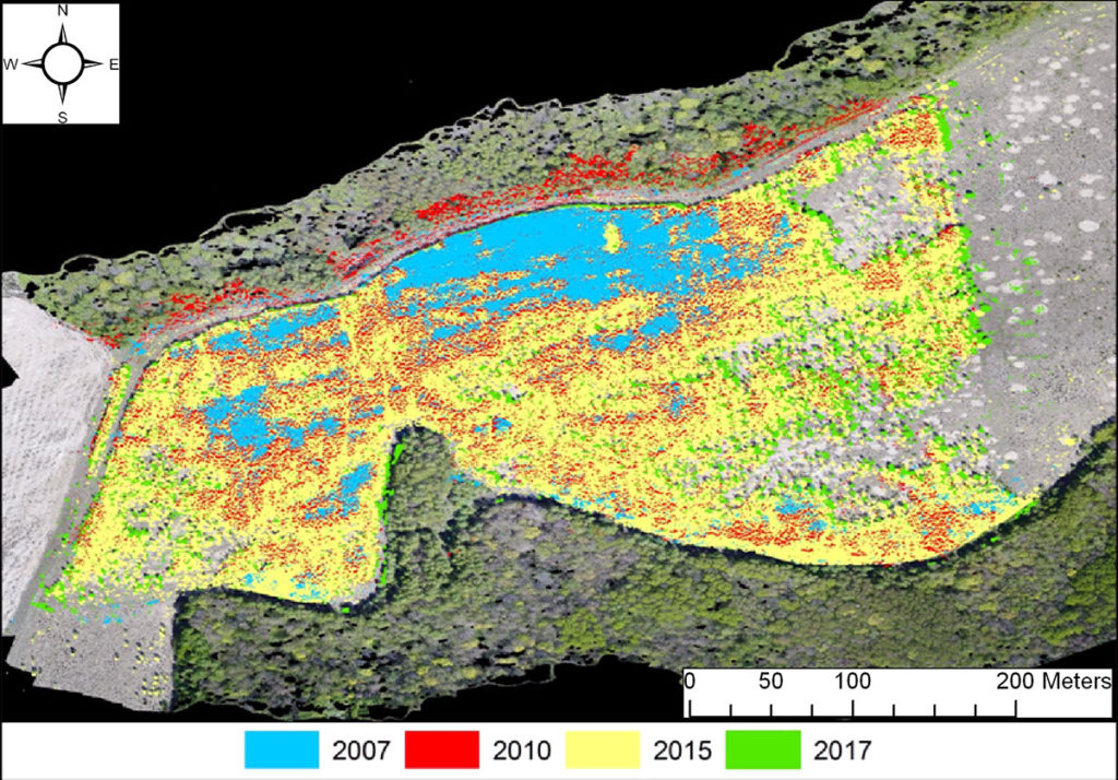
Figure 3. Change of overgrowth of tree vegetation on the fallow. Compiled on the basis of the results of satellite imagery and UAV material photointerpretation
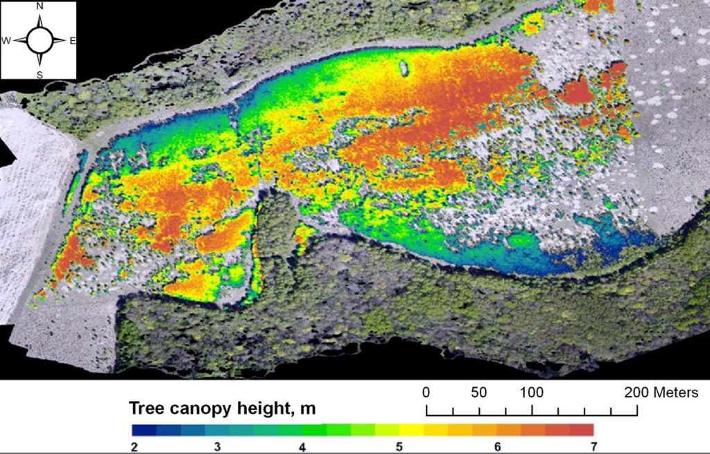
Figure 4. The height of the tree canopy formed on the fallow by 2018. Created on the basis of materials of a multi-seasonal UAV survey
In the first years after the cessation of agricultural use (2004–2009), the fallow parts adjacent to woodland showed very quick and intensive regeneration of tree vegetation, but as of 2018 the formed canopy was very low in height (3–4 m), with the maximum stem density throughout the entire fallow (up to 7 trunks per m2) and crown closure, the cessation or substantial slowing of vertical growth during 2013–2017. In the central part of the fallow, the regeneration of tree vegetation began only 8–10 years after the termination of plowing, and most likely had a focal character. In 2015–2017, there was a sharp increase in the vertical growth of stands up to 30 cm over the period (Fig. 5), with maximum heights of the formed tree canopy throughout the entire fallow (6–7 m), lower density of individual trunks and lower crown closure (Fig. 6).
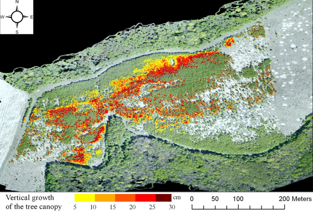
Figure 5. Vertical growth of the tree canopy on the fallow in 2015–2017. Based on the materials of a multi-temporal UAV images
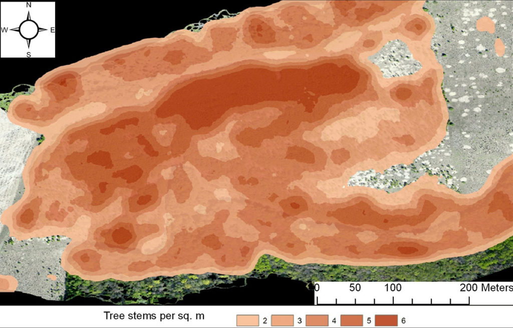
Figure 6. Density of the tree stand formed on the fallow since the termination of its agricultural use, 2005–2017. Based on the materials of multi-temporal UAV surveys
Remarkably, clear boundaries of the fallow were preserved for the entire period of monitoring, created in the west by a local road, and by a meadow plot, used for pasture, in the east, which prevents tree vegetation from growing here. The peripheral areas of the fallow adjacent to these borders have lower tree stand density and crown closure.
CONCLUSION
Combining ultra-high-resolution satellite images with the materials of multi-temporal optical ultra-highly-detailed UAV survey allowed us to assess the structural parameters the changes over time of the tree and shrub vegetation forming on the fallow, to identify and map the spatial differentiation of the speed and pattern of post-agrogenic succession on the fallow land unused since 2005. Feasibility of data obtained by multi-temporal optical aerial ultra-low-altitude UAV survey was shown for the delineation and quantitative morphometrical analysis of digital models of tree canopy heights. We found that, in general, since the removal of the land from agriculture, during 2005–2018, a closed monodominant tree cover formed almost throughout the entire fallow. At the same time, post-agrogenic renewal of tree vegetation was characterized by significant spatial heterogeneity, which was clearly seen at the local level, and it proceeded with different speed and intensity of overgrowing.
ACKNOWLEDGEMENTS
The research is carried out as part of the state assignment of the Institute of Geography of the Russian Academy of Sciences «Geoinformation and cartographic analysis and remote monitoring of the interaction between nature and society» No. АААА-А19-119022190168-8.
REFERENCES
Alcantara C., Kuemmerle T., Baumann M., Bragina E.V., Griffiths P., Hostert P., Knorn J., Müller D., Prishchepov A.V., Schierhorn F. et al., Mapping the extent of abandoned farmland in Central and Eastern Europe using MODIS time series satellite data, Environmental Research Letters, 2013, Vol. 8, No. 3. URL: https://iopscience.iop.org/article/10.1088/1748-9326/8/3/035035 (July 22, 2018).
Dandois J.P., Ellis E.C., High spatial resolution three-dimensional mapping of vegetation spectral dynamics using computer vision, Remote Sensing of Environment, 2013, Vol. 136, pp. 259-276.
de Beurs K., Ioffe G., Nefedova T., Henebry G., Land Change in European Russia: 1982–2011, Land-Cover and Land-Use Changes in Eastern Europe after the Collapse of the Soviet Union in 1991, Springer, Cham, 2017, pp. 223-241.
de Beurs K.M., Ioffe G., Use of Landsat and MODIS data to remotely estimate Russia’s sown area, Journal of Land Use Science, 2014, Vol. 9, No. 4, pp. 377-401.
Estel S., Kuemmerle T., Alcántara C., Levers C., Prishchepov A., Hostert P., Mapping farmland abandonment and recultivation across Europe using MODIS NDVI time series, Remote Sensing of Environment, 2015, Vol. 163, pp. 312-325.
Ke Y., Quackenbush L.J., A review of methods for automatic individual tree-crown detection and delineation from passive remote sensing, International Journal of Remote Sensing, 2011, Vol. 32, pp. 4725-4747.
Koroleva N.V., Tihonova E.V., Ershov D.V., Saltykov A.N., Gavriljuk N.A., Pugachevskij A.V., Ocenka masshtabov zarastanija nelesnyh zemel’ v nacional’nom parke «Smolenskoe Poozer’e» za 25 let po sputnikovym dannym Landsat (Scales of overgrowth on non-forested lands of Smolenskoe Poozer’e national park: an assessment for the 25 years on remote sensing Landsat data) // Lesovedenie, 2018. No. 2. pp. 83-96.
Lesiv M., Schepaschenko D., Moltchanova E., Bun R., Dürauer M., Prishchepov A., Schierhorn F., Estel S., Kuemmerle T., Alcantara C., Concepcion P.C. et al., Spatial distribution of arable and abandoned land across former Soviet Union countries, Scientific Data, 2018, No. 5. URL: https://doi.org/10.1038/sdata.2018.56.
Lisein J., Pierrot—Deseilligny M., Bonne, S., Lejeune, P.A., Photogrammetric workflow for the creation of a forest canopy height model from Small Unmanned Aerial System Imagery // Forests, 2013, Vol. 4, No. 4, pp. 922-944.
Lyuri D.I., Gorjachkin S.V., Karavaeva N.A., Denisenko E.A., Nefedova T.A., Dinamika sel’skohozjajstvennyh zemel’ Rossii v HH veke i postagrogennoe vosstanovlenie rastitel’nosti i pochv (Dynamics of Agricultural lands of Russia in XX century and Postagrogenic Restoration of vegetation and soils) M.: GEOS, 2010, 426 p.
Mongus D., Zalik B., An efficient approach to 3D single tree-crown delineation in LiDAR data, ISPRS Journal of Photogrammetry and Remote Sensing, 2015, Vol. 108, pp. 219-233.
Reviewer: PhD in biology, research officer M.A. Medvedeva


