- DOI 10.31509/2658-607x-202251-98
REVIEW OF OPEN SOURCE QGIS FORESTRY PLUGINS
![]()
С текстом оригинальной статьи Вы можете ознакомиться по ссылке
Original Russian Text © 2021 E. S. Podolskaia published in Forest Science Issues Vol. 4, No. 2, Article 86
E. S. Podolskaia
Center for Forest Ecology and Productivity of the Russian Academy of Sciences
Profsoyuznaya st. 84/32 bldg. 14, Moscow 117997, Russian Federation
E-mail: podols_kate@mail.ru
Received 13.04.2021
Revised 12.05.2021
Accepted 21.06.2021
To date, the forestry industry has obtained certain experience in implementing Open Source software. The article describes Open Source QGIS-plugins for the tasks of forest fires and forest resources monitoring and management in research and applications. The functionality analysis performed aimed to simplify the selection of tools for a forest geoinformation project in desktop and web versions. The article presents a brief description of presently downloadable QGIS (version 3.18.1) forestry plugins. The analysis of external QGIS-plugins for working with forest resources and fires has shown the heterogeneity of research. This prevents from identifying trends so far. An option for future research subjects may be development of plugins with available data as cartographic services for territories of different spatial coverage, taking into account that archived data and their availability is a key asset in the forestry. Subject-related forest scope in the present-day repository of QGIS-plugins tends to be relatively limited. Transport and environmental applications implemented in the form of GIS tools are more numerous and can solve individual tasks in the orest project. A review of plugins functionality, compatibility to the core QGIS and their performance should be performed on a regular basis, following new QGIS versions.
Keywords: forest resources, forest fires, forestry management, QGIS, plugin
According to the strategy for the development of the forest complex in the Russian Federation until 2030 (Decree of the Government of the Russian Federation dated September 20, 2018 No 1989-р), forestry is an industry for reproducing forests, protecting them from fires, harmful organisms, and other negative factors; regulation of forest utilization and record of forest resources with the purpose of meeting the needs of the economy in wood and other forest products while preserving the environmental and social functions of the forest.
Awareness of the industry scope implies the need for tools, especially geoinformation-based ones, with the help of which the assigned thematic tasks are to be addressed. By the beginning of the third decade of 21th century, forestry has accumulated some experience in using Open Source software. Namely, in 2010, the branches of the Federal State Institution Russian Centre of Forest Health attempted to design blueprints for the state of plantings and the number of pests in Open Source QGIS (Krylov et al., 2012). International examples are presented by such subject-related projects as the construction of forest fire danger maps for local government in QGIS and GRASS (https://clck.ru/bVQE3; https://clck.ru/bVQE8). Paper (Korosov, Zorina, 2016) considers environmental issues of implementing QGIS in the learning guide. Open Source is widely used in a variety of geographical analysis’s instruments. In particular, a work done by Lovelace (2021) presents a large contemporary overview of tools for geographical analysis. It provides a description of tools’ ecosystem, dynamic in time and content and currently consists of around 25 items.
Systematization of currently used geoinformation tools to solve forestry issues could be useful in the form of links list with description. This list could be used when starting a new subject-related forest GIS project. In the present case, the need for such a description arose at the starting point of the interdisciplinary working group “Mapping forestry ecosystem services”, established at the CEPF RAS in February, 2021.
In recent years the number of solutions for QGIS, which occupies a remarkable niche in the modern GIS landscape, has been increasing (https://gisgeography.com/mapping-out-gis-software-landscape/). There are examples of books describing technology for a specific thematic task. For example, QGIS for remote sensing in the forestry industry and agriculture (QGIS and applications in agriculture and forest, 2018) contains a section on the recognition and mapping of continuous logging on the optical satellite images. Basic operations with raster and vector data are performed using standard or core plugins. They are mandatory for any subject-related area, combined in a set of so-called top-5-10 tools (https://digital-geography.com/top-5-qgis-plugins/) or plugins for solving a field-specific task (e. g., https://clck.ru/bVQEN). Often a plugin release in the repository is accompanied by a link to the article published (e. g., in research community ResearchGate, https://www.researchgate.net) with the information on its development, for example, in the works by M. Jung (2013) and L. Duarte et al. (2018). An educational module for the forestry issues is included in the documentation, an example for QGIS version 3.16 (https://clck.ru/bVQEQ).
The article aims to provide a review of plugins for solving forestry challenges to monitor and to manage forest fires and forest resources in the desktop version of Open Source QGIS 3.18.1, which is current as of April, 2021. Selected plugins are aimed to solve the transportation problem of land access and transport modeling at different degree. These topics are in the scope of CEPF RAS Forest ecosystems monitoring laboratory’s activity (http://cepl.rssi.ru/transport-modeling/), including using Open Source software and Open data Open Street Map (OSM, https://www.openstreetmap.org/), in particular, in the work by Podolskaia et al. (2020). QGIS tools application experience is systematized in a manual by Podolskaia (2020).
MATERIALS AND METHODS
QGIS (Quantum GIS) with a plugin library (QGIS plugins web portal), located at https://plugins.qgis.org/plugins/, currently holds the leading position among Open Source software used in scientific research. Plugins are software modules used to extend the standard functionality of QGIS application in desktop and web-projects, solving a field-specific task using custom or predefined data sets, services, classifications and formats (a typical example is available at https://clck.ru/bVQES). Plugins can be internal (core) and external (https://clck.ru/bVQEV). Core plugins are written in C++ or Python and included in every new QGIS version released; QGIS core developers maintain them. Python-developers write and support external plugins worldwide.
In this review we consider upon external plugins. The interface of such plugins can be presented in different languages (English is a priority) depending on the target audience, data used in the plugin and a country of development. Plugins functionality should be compatible to the coming QGIS versions. Plugin performance depends on the technical capacities of hardware which hosts the plugin. Speed and uninterrupted Internet connection is of primary importance when there is a need to connect to the third-party services, including map services. The variety of plugins available in the repository (as of April 8, 2021) for forest infrastructure and forest fires is presented on the Fig. 1.
(a)
(b)
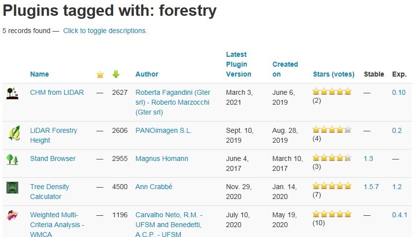
Figure 1. Plugins on forest infrastructure and forest fires (a) and tools to solve forestry tasks (search by the keyword «forestry» (b) https://plugins.qgis.org/plugins/tags/forestry/)
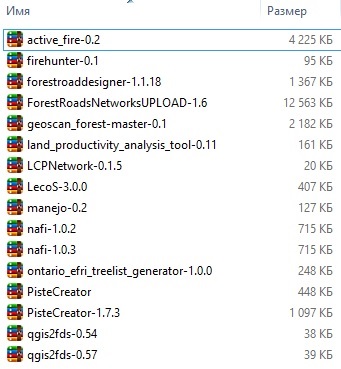
Plugin Builder (a plugin for plugins), was already available in the first versions of QGIS 1.x and 2.x (https://plugins.qgis.org/plugins/pluginbuilder/) and has been used since 2011 to create the templates for plugins themselves. The tools for working with OSM project data currently prevail in terms of the number of views and downloads. One of the oldest plugins for the forest industry is the plugin for landscape ecology statistics called LecoS (Landscape Ecology Statistics, https://plugins.qgis.org/plugins/LecoS/), which is available for use starting from QGIS 1.8. It is developed in Python and uses its SciPy and Numpy libraries to calculate basic and additional metrics of landscape analysis sourced from FRAGSTATS software (https://clck.ru/bVQEe).
Some plugins available are indicated as experimental. An example is a module to create a network of routes for accessing forest resources and forest fires (LCPNetwork, https://plugins.qgis.org/plugins/LCPNetwork/). It implements Dijkstra algorithm, which is considered classic for transport applications and is used to build optimal routes between features of two point vector layers. The result of the plugin is an accumulated cost map for each of the points and a linear layer of traffic routes. Table 1 summarizes the description of plugins for solving forestry issues (repository at https://plugins.qgis.org/ as of April 8, 2021). The status of all plugins in Table 1 is defined by the authors as non-experimental, with the exception of Manejo.
Table 1. External QGIS plugins for forest resource management and forest fire monitoring
| Plugin name and link to the QGIS plugins repository
|
Description | Links to additional Internet sources | |
| Active Fire Data within 24 hours (MODIS)
https://clck.ru/bVQGT |
The plugin loads to QGIS data on the latest wildfires in the world over the past 24 hours, detected according to MODIS data | https://github.com/Themapworkshop/Active-Fire-Plugin | 3.0 |
| North Australia & Rangelands Fire Information (NAFI) Map Services
https://clck.ru/bVQGZ |
The plugin loads a set of mapping services that display fire-affected areas and burning fire sites in Australia | https://github.com/nafi-org/nafi-qgis; | 3.4.0 |
| Manejo (Managing Forest Areas Under The Power Lines Network)
https://clck.ru/bVQGe |
The plugin is for managing the forest areas under power lines; allows projecting lines according to reference points; analyzing the territory using buffers | https://github.com/romariocarvalhoneto/Manejo | 3.0.0 |
| qgis2fds | The plugin exports the raster surface to NIST FDS modeling system (https://pages.nist.gov/fds-smv /) for subsequent modeling of fire dynamics, gas and heat flows | https://github.com/firetools/qgis2fds; | 3.14–3.16 |
| FireHunter | The plugin creates a Sentinel-2 mosaic for a rectangular area in a given time interval | https://github.com/olegruk/firehunter | 3.16 |
RESULTS AND DISCUSSION
A group of three external plugins (Active Fire, NAFI Fire Maps and Manejo) was selected for testing in QGIS version 3.18.1.
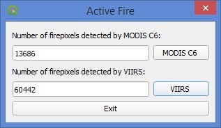
Two layers of shp-format in geographical coordinates WGS84 “MODIS C6 1 km” (Moderate Resolution Imaging Spectroradiometer) with a spatial pixel resolution of 1000 m and «VIIRS 375 m» (Visible Infrared Imaging Radiometer Suite) with a spatial resolution of 375 m are available for download in the Active Fire plugin. Both sources are well known in scientific and applied research for monitoring wildfires (forest fires). Their descriptions are available at https://clck.ru/bVQGp.
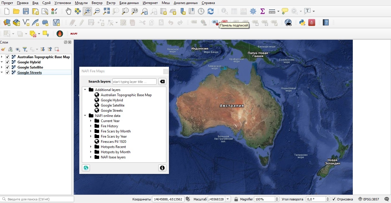
NAFI Fire Maps plugin allows uploading to the QGIS desktop project up-to-date and archived data (retrospectively up to 2000 inclusively) on wildfires in Australia, one of the continents with a constant long-term wildfire hazard. Fire scars and cleaned up hotspots, distributed by months and years, are included in the sets available. Fire data are accompanied by a block of general geographic layers within the area of interest mainly in northern Australia (NAFI base layers) and Google layers (a standard set of streets, satellite base map and their hybrid) for the whole world. The data are available in the Mercator projection as WMS and WMST services. The set of project data is presented as a web-GIS application hosted at https://firenorth.org.au/nafi3/with zooming, changing the legend, saving and printing options for the selected map part (Fig. 2). Downloading a data file in kml-format for viewing, for example, in Google Earth, is also possible as an option. Archived data 2000–2020 can be downloaded in raster (geotiff) and vector (shp) formats at https://firenorth.org.au/nafi3/views/data/Download.html.
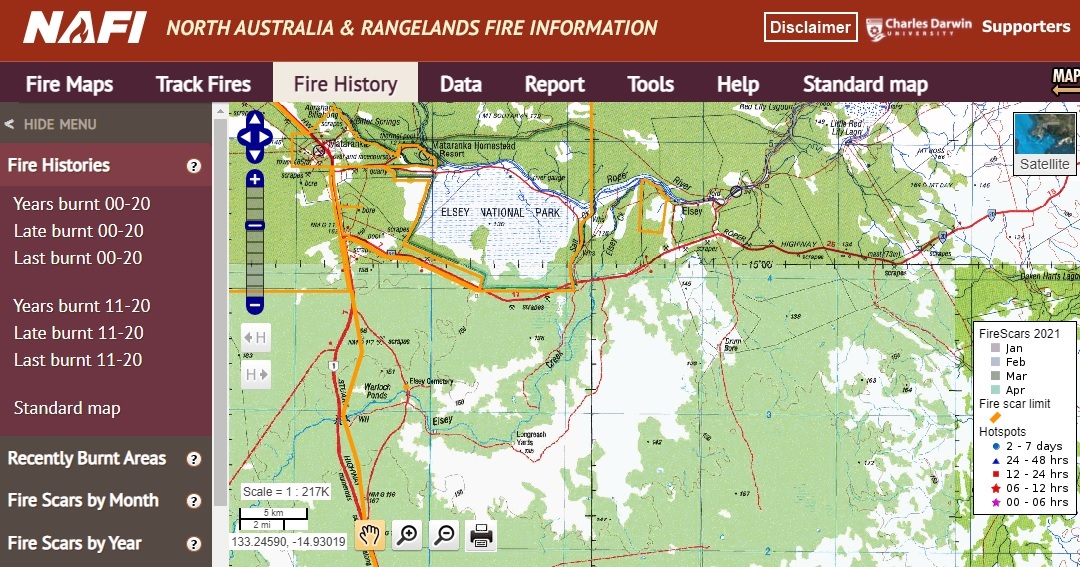
Figure 2. View and data operation options in web GIS application of North Australia & Rangelands Fire Information (NAFI) project
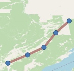
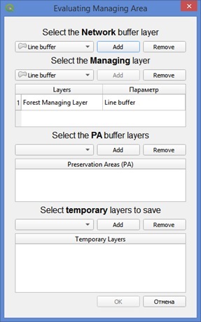
Manejo (Managing Forest Areas Under The Power Lines Network, https://plugins.qgis.org/plugins/manejo/), is a plugin for managing forest areas located under power lines. It creates a network of lines from points (power towers), then makes buffer and protective zones. Screenshots of test results are in the Table 2 (repository at https://plugins.qgis.org/ as of April 8, 2021).
Table 2. Test results for external QGIS plugins for forest resource management and forest fire monitoring
| Plugin | Plugin interface | View of the results screen
|
| Active Fire
|
 |

|
| NAFI Fire maps
|
 |
|
| Manejo | 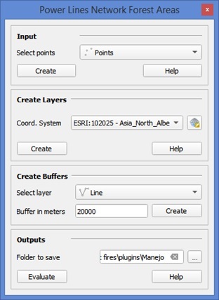 |
|


The plugins published are very heterogeneous in terms of number and content, as shown in the Tables 1 and 2. It is difficult to make any assumptions about trends in the development and functionality of tools for monitoring wildfires (forestfires) and forest resources management. The shp-file remains as a working format for the desktop QGIS in these plugins. The data are available in WMS format, which could be useful to view the results of plugins implementation in other GIS applications. The most commonly used coordinate system for the world coverage data is WGS84. For the continents and countries some specific systems are used, for instance, an Australian coordinate system. An ability to access archived data is an advantage for solving forestry issues. In this sense, the NAFI Fire Maps project for Australia may serve as example as it provides access to the archives and current data. In this project QGIS plugin has become a continuation and extension of the web-GIS section (https://www.gaiaresources.com.au/fire-mapping-qgis-plugin/).
At the end of the discussion we have to note that there are still few examples in the QGIS-plugin repository for operating data on the forests, forest fires, resources and infrastructure. Notably, as of April 13, 2021, the «forest» query (https://clck.ru/bVQFY) in the repository resulted in a list of 12 plugins of different status. The «resources» query (https://plugins.qgis.org/search/?q=resources) — 5 plugins, of which one relates to the forest resources (Ontario EFRI Treelist Generator). Numerous transport, infrastructural and environmental applications are related to the present research. The «routing» query (https://plugins.qgis.org/search/?q=routing) shown a list of 31 plugins; the «ecology» query (https://plugins.qgis.org/search/?q=ecology) — 23 plugins; the «transport» query (https://plugins.qgis.org/search/?q=transport) — 8 plugins; the «forest» query (https://plugins.qgis.org/search/?q=forestry) — 6 plugins.
CONCLUSION
The niche of economic and infrastructural forest applications in the up-to-dated repository of QGIS-plugins is relatively limited. For example, the plugins mentioned in the article are out of the list of first 20 popular and downloadable plugins at https://plugins.qgis.org/plugins/popular/ (for the library out of total of 1.380 plugins as of April 08, 2021). Among the actual examples for the forestry, FireHunter plugin can be cited. It was introduced in April 2021 and occupies the 4th line in the list of new plugins (https://plugins.qgis.org/plugins/fresh/) out of 19 as of April 8, 2021.
A way for further research may be a plugins development with linked and pre-processed data sets for a continent, region, or a country administrative unit. The plugins promising for transport modeling in the forestry are Forest Road Designer (https://clck.ru/bVQEn), as well as Forest Roads Network (https://clck.ru/bVQFT) and Road Emission Calculator (https://plugins.qgis.org/plugins/RoadEmissionCalculator/). We are planning to devote a separate study to test these plugins using data on the key forest areas in Russia.
Development, publication in the repository and testing of QGIS-plugins by users as well as QGIS-releases currently continue to be a very dynamic area where update intervals vary from a quarter to a half year, so the review of plugins functionality and performance, and their compatibility to the core QGIS application should be done within appropriate time frame.
FINANSING
The study was performed within the framework of the state CEPF RAS assignment 121121600118-8.
REFERENCES
Duarte L., Silva P., Teodoro A. C., Development of a QGIS Plugin to Obtain Parameters and Elements of Plantation Trees and Vineyards with Aerial Photographs, International Journal of Geo-Information, 2018, Vol. 7, No 3, P. 109. DOI: 10.3390/ijgi7030109
Government Order, 20.09.2018, Nо 1989-r (edited 28.02.2019).
Jung M., LecoS — A QGIS plugin for automated landscape ecology analysis, PeerJ PrePrints, 2013, pp. 1–10, DOI: 10.7287/peerj.preprints.116v2
Korosov A. V., Zorina A. A., Jekologicheskie prilozhenija Quantum GIS: uchebnoe posobie dlja studentov biologicheskih special’nostej (QGIS environmental applications), Petrozavodsk: PetrGU, 2016, 211 p.
Krylov A. M., Vladimirova N. A., Malahova E. G., Ispol’zovanie svobodnyh GIS v sisteme distancionnogo lesopatologicheskogo monitoringa (Open Source GIS in the remote forest pathology monitoring system), Lesnoj vestnik, 2012, No 1. pp. 148–152.
Lovelace R., Open source tools for geographic analysis in transport planning, J. Geogr. Syst., 2021, pp. 1–32, DOI: 10.1007/s10109-020-00342-2 (2021, 12 May).
Podolskaia E., Osnovy raboty v geoinformacionnom prilozhenii Open Source QGIS: geodannye, koordinaty, bazovaja funkcional’nost’, kontrol’ kachestva dannyh, oformlenie i publikacija proekta (Basics of working in Open Source QGIS: geodata, coordinates, basic functionality, data quality control, design and publication of the project), Lab-publisher, 2020, 52 p.
Podolskaia E., Ershov D., Kovganko K., Comparison of data sources on transport infrastructure for the regional forest fire management. Reyer, C., Bilogub, M., Mahnken, M., Gutsch, M., Kruger, K., Ramming, A., Reineking, B., Seidl, R., Schelhaas, M.-J., Makela, A., Verkerk, H. (Eds.), Managing forests in the 21st century: Book of abstracts, Managing forests in the 21st century, Conference at the Potsdam Institute for Climate Impact Research, Potsdam, 2020, 59 p., DOI: org/10.2312/pik.2020.002
QGIS and applications in agriculture and forest, Baghdadi N., Mallet C., Zribi M. (Eds.), Vol. 2, Wiley-ISTE, 2018, 364 p.
Reviewer: Candidate of Technical Sciences O. V. Perfileva


