- DOI 10.31509/2658-607x-2019-2-2-1-8
Identification of drainage basin borders at local spatial scale
Original Russian Text © 2018 A.S. Plotnikova, A.O. Kharitonova, published in Forest Science Issues Vol. 1, No. 1, pp. 1-10
![]() © 2019 г.
© 2019 г.
A.S. Plotnikova, A.O. Kharitonova
1Center for Forest Ecology and Productivity of the RAS
Profsoyuznaya st. 84/32 bldg. 14, Moscow, 117997, Russia
E-mail: alexandra@ifi.rssi.ru
The basin concept to nature management is used in various studies on ecological monitoring of terrestrial ecosystems. The objective of this study is to identify the borders of drainage basins on the territory of Pechora-Ilych Nature Reserve and its surroundings – Kuryinsky and Yakshinsky local forestries. Digital elevation models (DEMs) ASTER GDEM Version 2, GMTED2010, and open access data of the drainage network at a scale of 1 : 1,000,000 were the inputs for the identification of drainage basin borders of the area of interest. These data were processed and analyzed with two geographic information systems, i. e. SAGA GIS and ArcGIS Desktop software. The present study involved pre-processing of the DEM data and identification of the drainage basin borders of the area of interest. Pre-processing of DEMs data included rasters’ cell size unification, filling sinks, and determining flow direction. Identification of drainage basin borders was performed in two ways using the Basin and Watershed tools of the Spatial Analyst module of the ArcGIS Desktop geographic information system. Analysis of the findings showed that the Basin tool was only able to identify basin borders of large rivers such as Pechora and Ilych. The Watershed tool using raster data on pour points is suitable to form basin borders of both large and small rivers.
Key words: basin analysis, GIS analysis, DEM, Pechora-Ilych Nature Reserve
As it is known, one of the most successful ways of spatial organization of geographical systems is the basin approach, which complements the landscape organization of objects and phenomena, highlighting their lateral and paragenetic connection (Simonov, Simonova, 2003). A drainage basin serves as an elementary unit of the territorial organization within this approach. A drainage basin is thought of as part of the land surface with the adjacent strata of soils wherefrom surface water and groundwater flow into a separate river or a river system (Geographic encyclopedic dictionary, 1988).
Various aspects of basin approach in nature management are reflected in the studies of national researchers – A.M. Trofimov (Trofimov et al., 2009), Ya.V. Kuzmenko (Kuzmenko et al., 2012), F.N. Lisetsky (Lisetsky et al., 2014), F.N. Milkov (Milkov, 1981), V.M. Smolyaninov (Smolyaninov et al., 2007), Methodical approaches… (2010) and other. The authors focus on the natural laws of a drainage basin as a geosystem, in particular on integrity, uniqueness, hierarchical pattern, resilience and self-regulation. The functional integrity of basins results from current vertical and horizontal relations and the balance between them. F.N. Milkov believes that a drainage basin is a paradynamic system with an active exchange of matter and energy, resulting from a combination of morphological, climatic, soil and hydrological conditions (Milkov, 1981). The paper (Smolyaninov et al., 2007) considers unidirectional flows of matter and energy within a drainage basin, which makes it an ideal object for natural environment monitoring.
Arguments in support of the rationality of environmental monitoring at the basin level are given in the study (Lisetsky et al., 2014). The authors describe the internal functional integrity of migration flows of surface water and groundwater runoff, dissolved substance and suspended solids, as well as objective natural borders of the basins. In the study of Kuzmenko with co-authors (Kuzmenko et al., 2012), drainage basins are seen as the most objective and natural basis for organizing rational nature management. The authors highlight the objectivity and relative simplicity of the identification of basin borders, which increases the representativeness of territorial units (Trofimov et al., 2009). Moreover, the basin concept of nature management makes it possible to use basins as a topological unit during the gradual transition from local to regional and national levels of analysis.
The objective of this study is to identify the borders of the drainage basins on the territory of Pechora-Ilych Nature Reserve and its surroundings, i.e. Kuryinsky and Yakshinski forestries. (Fig. 1).
MATERIALS AND METHODS
Within the area of interest which is located north of the 60° latitude, the set of freely available digital elevation models (DEMs) is limited, and the available ones more often than not have distortions and incomplete data. Global digital elevation models that are currently in open access provide information about the topography of the area of interest, and the degree of data accuracy should depend on the study objectives (Mineev et al., 2015). Manual creating of a topographic maps-based DEM results in more accurate DEMs compared to global models but requires considerable time. This paper does not require accurate morphometric parameters so we decided to use a global DEM, which is in open access, to achieve the study objective.
Currently, there are a lot of DEMs provided free of charge or on a commercial basis, varying in both territory coverage and accuracy of data: GMTED2010, ASTER GDEM2, SRTM C-band, SRTM X-band, SPOT DEM, Next Map, NextMap World 30, TanDEM-X Global DEM, World 3D Topographic Data and other. However, of all the DEMs listed only GMTED2010, ASTER GDEM2, SRTM C-band, and SRTM X-band are in open access. It is also worth noting that the area of interest is located between 61 and 64° north latitude. Of all the available models, only GMTED2010 and ASTER GDEM cover the area of interest. ASTER GDEM is more accurate than GMTED2010, but it tends to omit some values, so it might be expedient to combine these two elevation models.
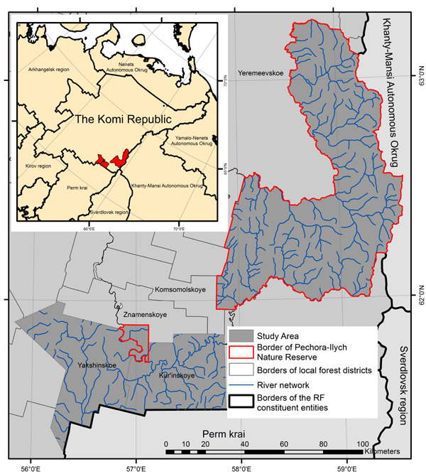
Figure 1. Area of interest: the Pechora-Ilych Nature Reserve, Kuryinsky and Yakshinsky forestries
Therefore open access ASTER GDEM Version 2 (Aster…, 2016) and GMTED2010 (Global…, 2015) digital elevation models and the data on the drainage network at a scale of 1 : 1 000 000 (Topographic basis…, 2014) became the input data for the identification of the drainage basin borders within the area of interest.
DEM data and identification of the drainage basin borders within the area of interest were processed in two geographic information systems: SAGA GIS and ArcGIS Desktop. It was decided to combine several GISs because SAGA GIS has a certain advantage over ArcGIS Desktop in the processing and analysis of digital elevation models; further work with a large amount of data was, however, more convenient and less time-consuming when using the ArcGIS Desktop system. The Spatial Analyst module in ArcGIS and the Terrain Analysis module in SAGA GIS make it possible to work with DEMs.
Processing of DEM data includes: unification of the DEMs rasters cell size, filling sinks, determining the flow direction. In order to analyze digital elevation models in both ASTER GDEM V. 2 and GMTED2010 it is necessary to resample these maps to a single grid cell size. The spatial resolution in ASTER GDEM V. 2 is 30 meters or 1 arcsecond, in GMTED2010 it is 225 m or 7.5 arcseconds. To resample digital elevation maps to resolution of 30 m the Resampling tool in SAGA GIS was used. Then Patching SAGA GIS tool was used to fill the missing ASTER GDEM V. 2 values with GMTED2010 values. Further processing of DEM data was performed in ArcGIS Desktop.
Filling sinks is necessary to remove small imperfections of the ASTER GDEM V. 2 that appeared due to data resolution or rounding off elevations to the nearest integer value (Tarboton et al. , 1991). The need to fill sinks is explained by the necessity to have a continuous raster layer of flow directions which will be created later. Filling sinks was done using the Fill tool in ArcGIS Desktop. As part of the flow direction determination, the Flow Direction tool creates a continuous raster layer that contains the direction of the biggest elevation decrease for each cell. Flow direction determination is described in detail in the article of (Plotnikova et al., 2017).
RESULTS AND DISCUSSION
The Spatial Analyst module of the ArcGIS Desktop geographic information system contains two tools that are able to define contributing areas, i. e. Basin and Watershed. As is known, the borders of drainage basins pass along watersheds that distribute the runoff around slopes. Drainage basins building operation Basin defines the borders of watersheds within the analysis window. The raster layer with flow direction is analyzed to find related units belonging to the same contributing area. Drainage basins are created by placing pour points at the edges of the analysis window and sinks. Next, the area above each pour point from which a flow passes to this point is determined. The result is a raster layer of drainage basins.
The results of the construction of drainage basin borders with the Basin tool for ASTER GDEM VERSION 2 DEM are shown in Figure 2. Overlaying of the constructed borders of drainage basins and the drainage network, shows that the Basin tool identifies only the basin borders of large rivers, i. e. Pechora and Ilych.
Just like the Basin tool, the Watershed module allows one to define a contributing area using a previously calculated flow direction raster. Unlike the Basin tool, the Watershed tool requires a separate file of pour points in raster or vector format. Pour points were created as a set of raster data by rasterizing the drainage network (Topographic basis…, 2014). Note also that this tool allows one to use the pour points selected by the user manually on the basis of the drainage network with their subsequent binding with the Snap Pour Point tool which corrects the position of pour points by binding them to the units with high total runoff, but this method is only relevant for small areas of interest. The Watershed tool, like the Basin tool, defines a contributing area above pour point. As a result of using the Watershed tool to construct the contributing areas, the basin borders of both large and small rivers were obtained (Fig. 3).
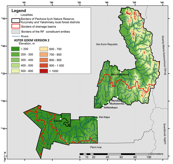
Figure 2. Borders of drainage basins produced by the Basin tool
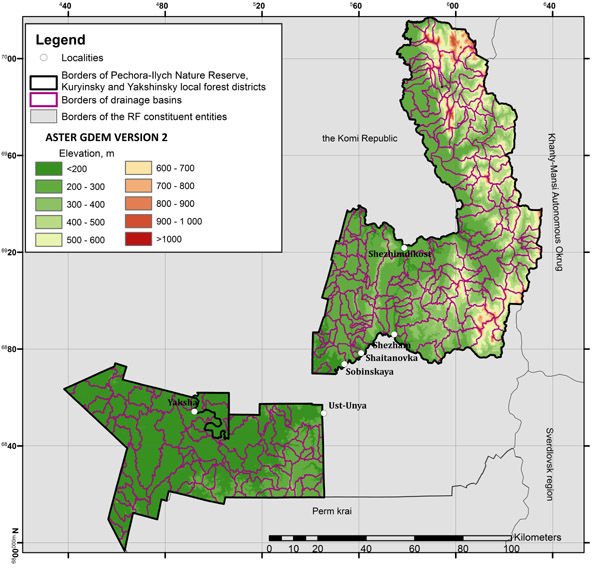
Figure 3. Borders of drainage basins produced by the Watershed tool
The obtained borders of drainage basins of small rivers will be further used as part of a comprehensive study of fire regimes of forest ecosystems at the local spatial level. Minimal spatial units for fire regimes mapping will be identified on the basis of the drainage basin borders.
The study has been made possible due to the financial support of the Russian Foundation for Basic Research (project No. 17-05-00300) and state assignment “Methodical approaches to the assessment of the structural organization and functioning of forest ecosystems”№ АААА-А18-118052400130-7.
Aleinikov A.A., Bakhmet O.N., Bobrovskii M.V., Braslavskaya T.Yu., Evstigneev O.I., Zhirin V.M., Zaugol’nova L.B., Kamaev I.O., Knyazeva S.V., Kravchenko T.V., Lugovaya D.V., Lukina N.V., Lyamtsev N.I., Novakovskii A.B., Orlova M.A., Rybalov L.B., Smirnova O.V., Tikhonova E.V., Toropova N.A., Eidlina S.P. et al. Metodicheskie podkhody k ekologicheskoi otsenke lesnogo pokrova v basseine maloi reki (Methodical approaches to the environmental assessment of forest cover in the basin of a small river), Moscow: KMK Scientific Press Ltd., 2010, 383 p.
Geograficheskij jenciklopedicheskij slovar’. Ponjatija i terminy (Geographical encyclopedic dictionary. Concepts and terms), Moscow: Sovetskaja Jenciklopedija, 1988, 253 p.
http://gis-lab.info/qa/vmap0-about.html, (2018, 12 July).
http://www.jspacesystems.or.jp/ersdac/GDEM/E/index.html, (2018, 7 June).
https://lta.cr.usgs.gov/GMTED2010, (2018, 1 June).
Kuz’menko Ja.V., Liseckij F.N., Narozhnjaja A.G. Primenenie bassejnovoj koncepcii prirodopol’zovanija dlja pochvovodoohrannogo obustrojstva agrolandshaftov (Application the basin concept of environmental management for soil-water safety arrangement of agrolandscapes), Izvestija Samarskogo nauchnogo centra Rossijskoj akademii nauk, 2012, Vol. 14. No. 1 (9), pp. 2432-2435.
Liseckij F.N., Grigor’eva O.I., Kirilenko Zh.A. Nauchnoe soprovozhdenie bassejnovoj organizacii prirodopol’zovanija v Belgorodskoj oblasti (Scientific support of the basin organization of nature management in the Belgorod region), Dvadcat’ devjatoe plenarnoe mezhvuzovskoe koordinacionnoe soveshhanie po probleme jerozionnyh, ruslovyh i ust’evyh processov (Twenty-ninth Plenary Interuniversity Coordination Meeting on Erosion, Channel and Wellhead Processes), Moscow: Interuniversity Scientific Coordination Council about the Erosion Problem, Channel and Wellhead Processes at MSU, 2014, pp. 106-107.
Mil’kov F.N. Bassejn reki kak paradinamicheskaja landshaftnaja sistema i voprosy prirodopol’zovanija (River basin as a paradynamic landscape system and nature management issues), Geografija i prirodnye resursy, 1981, No. 4, pp. 11-17.
Mineev, A.L., Kutinov, Ju.G., Chistova, Z.B., Poljakova, E.V. Podgotovka cifrovoj modeli rel’efa dlja issledovanija jekzogennyh processov severnyh territorij Rossijskoj Federacii (Preparation of a digital elevation model for the study of exogenous processes in the northern territories of the Russian Federation), Prostranstvo i Vremja, 2015, No. 3(21), pp. 278-291.
Plotnikova A.S., Ershov D.V., Kharitonova A.O. Ispol’zovanie GIS-tehnologij pri kartografirovanii pozharnyh rezhimov lesnyh jekosistem Pechoro-Ilychskogo zapovednika (Gis Technologies Application for Forest Fire Regimes Mapping Over Pechora Natural Reserve), II Mezhdunarodnaya nauchno-prakticheskaya konferentsiya “Geodeziya, kartografiya, geoinformatika i kadastry. Ot idei do vnedreniya” (II International Conference on Applied Science “Geodesy, Cartography, Geoinformatics and Cadastre. From idea to application”), Saint Petersburg, 8-10 November, 2017, Saint Petersburg: Politehnika, 2017, pp. 464-470.
Simonov Ju.G., Simonova T.Ju. Rechnoj bassejn i bassejnovaja organizacija geograficheskoj obolochki (River basin and basin organization of the geographical shell), In: Jerozija pochv i ruslovye process (Soil erosion and channel processes), Moscow, 2003, Issue 14, pp. 7-32.
Smol’janinov V.M., Degtjarev S.D., Shherbinina S.V. Jekologo-gidrologicheskaja ocenka sostojanija rechnyh vodosborov Voronezhskoj oblasti (Ecological-hydrological assessment of the Voronezh Region river basins state), Voronezh: Istoki, 2007, 133 p.
Tarboton D.G., Bras R.L., Rodriguez–Iturbe I., On the Extraction of Channel Networks from Digital Elevation Data, Hydrological Processes, 1991, Vol. 5, No. 1, pp. 81-100.
Trofimov A.M., Rubcov V.A., Ermolaev O.P. Regional’nyj jekologicheskij analiz (Regional environmental analysis), Kazan: Brig, 2009, 260 p.
Reviewer: PhD in biology Medvedeva M.A.


